
WinGPS™ Marine: Navigation on board using your tablet or smartphone.
With this app, route and waypoint navigation on nautical charts is easier than ever. With weather predictions and AIS you can create extra safety on board because you know what's coming.
This app is developed for navigation from sailing and motor yachts, to sloops and kayaks. Did you charter a boat, are you going diving or sport fishing? Then also use this app!
HIGHLIGHTS
• Navigate on high quality water charts.
• North-up GPS follow mode.
• Very user friendly way to create and edit waypoint and routes.
• Easy management of tracks, charts, routes and waypoints.
• Worldwide wind, air pressure, and rainfall prediction.
• Independent navigation system thanks to the internal GPS of your tablet or smartphone.
• Connect AIS and GPS wirelessly using a WIFI or Bluetooth connection.
• Avoid collisions with the velocity vectors of AIS vessels around you.
• The man-overboard button marks the position of the lost crew member and helps you find it.
IN-APP PURCHASE
After purchasing WinGPS™ Marine you unlock the full features of the app. Check out the various possibilities on www.wingpsmarine.com.
When first installing the app you will get the Lite version of WinGPS™ Marine.
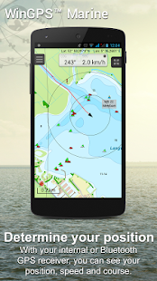
This version is limited functionality. With your GPS (internal or bluetooth) you get the SOG and COG and you will see the current position on your screen.
WinGPS™ Marine is the navigation app that allows true marine navigation on your Android device. In this app you can use the digital nautical charts for route planning with GPS via WIFI or bluetooth. You can also get data from AIS, GRIB meteo and record the tracks you have sailed. Use the built-in "timebar" to see the developments of the wind, rain, air pressure and AIS plotted on the screen.
The WinGPS™ Marine Plus upgrade provides you all the best of the Marine Apps. This advanced navigation app helps you plan routes under every condition. You can connect your board system using a wireless connection and use all this data to your advantage. The worldwide tidal & current predictions can be displayed in the data plotter, and on your chart screen.
CHART COVERAGE & INSTALLING CHARTS
When starting WinGPS™ Marine you will automatically use the free charts of OpenStreetMap. You can also download the free world chart via the chart manager.
For safe navigation you can best use digital water charts which Stentec offers you in the Google Play ™ store or in the online shop on www.stentec.com. When purchasing a chart you get a license code which you can activate on 2 separate machines (with a third backup activation). This enables you to use the charts on your Android device as well as on your laptop/PC.
If you purchased charts using Google Play™, you need to connect them with your account to use them in WinGPS™ Marine. You can do this 2 hours after purchase. If you purchased the charts via www.stentec.com, this will go automatically.
If you login in WinGPS™ Marine, you can select your DKW chart licenses in the chart manager to download and update for use in the app. The charts are immediately ready for use!
Examples of DKW Charts are: Stentec’s DKW charts, UKHO, BSH, Imray, Delius Klasing and the DKW 1800 series with weekly BaZ update service.
On your PC you can download the free BSB charts of for example NOAA. After installation with the DKW Manager, you can copy these charts to your tablet. The easiest way to do this is with a USB cable.
Examples of NOAA/BSB charts are: United States, Brazil, New Zealand, and all charts you create with DKW Builder (scanned charts).
USER FEEDBACK
We are very interested in your experiences with this app and your suggestions so that we can use it to improve this app. If you got any suggestions, please send an e-mail to helpdesk@stentec.com.
WinGPS™海洋:导航使用平板电脑或智能手机板上。
有了这个程序,在海图航线和航点的导航比以往更容易。随着天气预测和AIS可以创建在船上额外的安全,因为你知道什么是未来。
这个程序是从帆船和游艇航行的发展,以单桅帆船和皮划艇。你有没有包机一艘船,你去不去潜水或钓鱼?然后还可以使用这个程序!
亮点
•浏览高品质的水图表。
•北了GPS跟踪模式。
•非常用户友好的方式创建和编辑航点和航线。
•的轨道,图表,航线和航点管理方便。
•全球风量,风压和降水预报。
•独立导航系统的感谢您的平板电脑或智能手机的内置GPS。
•连接AIS和GPS使用无线WiFi或蓝牙连接。
•避免碰撞与AIS你周围血管的速度矢量。
•该名男子落水按钮,标志着失去了船员的位置,并帮助你找到它。
应用程序内购买
购买WinGPS™海洋后解锁应用程序的全部功能。检查出www.wingpsmarine.com的各种可能性。
当第一次安装的应用程序,你会得到精简版的版本WinGPS™海洋。
这个版本是有限的功能。有了您的GPS(内部或蓝牙),你得到的SOG和COG,你会看到屏幕上的当前位置。
WinGPS™海洋是导航的应用程序,让你的Android设备上真正的海洋航行。在这个程序,你可以通过WIFI或蓝牙使用数字海图的路线规划与GPS功能。您也可以从AIS,GRIB气象数据,并记录你的航行轨道。使用内置的“时间栏”看风,雨,气压的发展和AIS绘制在屏幕上。
该WinGPS™海事升级服务为您提供一切最好的海洋应用程序的。这种先进的导航应用程序可帮助您规划每个条件下的路线。您可以使用无线连接连接您的车载系统,并使用这些数据,你的优势。世界范围的潮流和当前的预测,可以显示在数据绘图仪,和图表屏幕上。
图表覆盖及INSTALLING图表
当开始WinGPS™海洋,你会自动使用OpenStreetMap的自由图表。您也可以下载免费的世界图表通过图表管理。
对于安全航行,您可以最好地利用数字水航海图,Stentec为您提供在谷歌播放™商店或在www.stentec.com的网上商店。当购买一个图表,你得到一个注册码,您可以在2个独立的机器激活(与第三备份激活)。这使您可以使用图表您的Android设备上,以及你的笔记本电脑/ PC上。
如果您购买了使用谷歌播放™的图表,你需要将它们与您的帐户才能使用它们WinGPS™海洋连接。你可以购买后做2小时。如果您购买通过www.stentec.com图表,这将自动转到。
如果您在WinGPS™海洋登录,就可以在图表管理器中选择您的DKW图表许可证下载和更新的应用程序使用。图表立即投入使用!
DKW图表的例子有:Stentec的DKW图表,UKHO,BSH,Imray,戴留斯Klasing和DKW 1800系列,每周巴兹更新服务。
在PC上,你可以下载例如NOAA免费BSB图表。安装与DKW管理器后,可以将这些图表复制到平板电脑。要做到这一点最简单的方法是用USB电缆。
诺阿/ BSB图表的例子是:美国,巴西,新西兰和你DKW生成器(扫描图)创建的所有图表。
用户反馈
我们是在你使用这个应用程序的经验,你的建议很感兴趣,所以我们可以用它来改善这个应用程序。如果你有任何建议,请发送电子邮件至helpdesk@stentec.com。
