WinGPS™ Marine: Navigation on board using your tablet or smartphone.
With this app, route and waypoint navigation on nautical charts is easier than ever. With weather predictions and AIS you can create extra safety on board because you know what's coming.
This app is developed for navigation from sailing and motor yachts, to sloops and kayaks. Did you charter a boat, are you going diving or sport fishing? Then also use this app!
HIGHLIGHTS
• Navigate on high quality water charts.
• North-up GPS follow mode.
• Very user friendly way to create and edit waypoint and routes.
• Easy management of tracks, charts, routes and waypoints.
• Worldwide wind, air pressure, and rainfall prediction.
• Independent navigation system thanks to the internal GPS of your tablet or smartphone.
• Connect AIS and GPS wirelessly using a WIFI or Bluetooth connection.
• Avoid collisions with the velocity vectors of AIS vessels around you.
• The man-overboard button marks the position of the lost crew member and helps you find it.
IN-APP PURCHASE
After purchasing WinGPS™ Marine you unlock the full features of the app. Check out the various possibilities on www.wingpsmarine.com.
When first installing the app you will get the Lite version of WinGPS™ Marine.
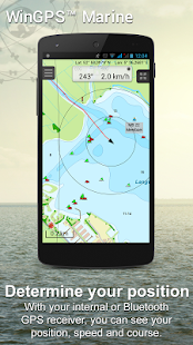
This version is limited functionality. With your GPS (internal or bluetooth) you get the SOG and COG and you will see the current position on your screen.
WinGPS™ Marine is the navigation app that allows true marine navigation on your Android device. In this app you can use the digital nautical charts for route planning with GPS via WIFI or bluetooth. You can also get data from AIS, GRIB meteo and record the tracks you have sailed. Use the built-in "timebar" to see the developments of the wind, rain, air pressure and AIS plotted on the screen.
The WinGPS™ Marine Plus upgrade provides you all the best of the Marine Apps. This advanced navigation app helps you plan routes under every condition. You can connect your board system using a wireless connection and use all this data to your advantage. The worldwide tidal & current predictions can be displayed in the data plotter, and on your chart screen.
CHART COVERAGE & INSTALLING CHARTS
When starting WinGPS™ Marine you will automatically use the free charts of OpenStreetMap. You can also download the free world chart via the chart manager.
For safe navigation you can best use digital water charts which Stentec offers you in the Google Play ™ store or in the online shop on www.stentec.com. When purchasing a chart you get a license code which you can activate on 2 separate machines (with a third backup activation). This enables you to use the charts on your Android device as well as on your laptop/PC.
If you purchased charts using Google Play™, you need to connect them with your account to use them in WinGPS™ Marine. You can do this 2 hours after purchase. If you purchased the charts via www.stentec.com, this will go automatically.
If you login in WinGPS™ Marine, you can select your DKW chart licenses in the chart manager to download and update for use in the app. The charts are immediately ready for use!
Examples of DKW Charts are: Stentec’s DKW charts, UKHO, BSH, Imray, Delius Klasing and the DKW 1800 series with weekly BaZ update service.
On your PC you can download the free BSB charts of for example NOAA. After installation with the DKW Manager, you can copy these charts to your tablet. The easiest way to do this is with a USB cable.
Examples of NOAA/BSB charts are: United States, Brazil, New Zealand, and all charts you create with DKW Builder (scanned charts).
USER FEEDBACK
We are very interested in your experiences with this app and your suggestions so that we can use it to improve this app. If you got any suggestions, please send an e-mail to helpdesk@stentec.com.
WinGPS™マリン:タブレットやスマートフォンを使用してボード上のナビゲーション。
このアプリでは、海図上のルートとウェイポイントナビゲーションがこれまで以上に簡単です。あなたが来るのか知っているので、天気予報やAISを使用すると、ボード上の余分な安全性を作成することができます。
このアプリは、セーリングやモーターヨットから、sloopsとカヤックへのナビゲーションのために開発されています。あなたチャーターボートをしたあなたはダイビングやスポーツ釣りに行くの?その後も、このアプリを使用します!
ハイライト
•高品質の水のチャートに移動します。
•ノースアップのGPSモードに従ってください。
•ウェイポイントとルートを作成、編集することは非常にユーザーフレンドリーな方法を。
•トラック、チャート、ルートやウェイポイントを簡単に管理。
•世界の風、気圧、および降雨予測。
•タブレットやスマートフォンの内蔵GPSに独立したナビゲーションシステムのおかげ。
•接続AISおよびGPSがワイヤレスで無線LANまたはBluetooth接続を使用して。
•あなたの周りのAIS船舶の速度ベクトルとの衝突を避けてください。
•マン・船外ボタンが失われた乗組員の位置をマークし、あなたがそれを見つけることができます。
アプリ内の購入
WinGPS™マリンを購入した後、あなたは、アプリのすべての機能のロックを解除します。 www.wingpsmarine.com上の様々な可能性をチェックしてください。
最初のアプリをインストールする際にはWinGPS™マリンのLiteバージョンを取得します。
このバージョンは、限られた機能です。あなたのGPS(内部またはブルートゥース)を使用すると、SOGとCOGを取得し、あなたの画面上の現在位置が表示されます。
WinGPS™マリンは、あなたのAndroidデバイス上の真の海洋ナビゲーションを可能にするナビゲーションアプリです。このアプリでは、無線LANやBluetooth経由でGPSをルート計画のためのデジタル海図を使用することができます。また、AIS、GRIB METEOからデータを取得し、あなたが航海しているトラックを録音することができます。風、雨、空気の圧力の進展を確認するために、組み込みの「タイムバー」を使用し、AISは、画面上にプロット。
WinGPS™マリンプラスのアップグレードは、あなたの海洋アプリのすべての最高を提供します。この高度なナビゲーションアプリでは、すべての条件の下でルートを計画するのに役立ちます。あなたは、ワイヤレス接続を使用してボードシステムを接続し、あなたの利点にすべてのデータを使用することができます。世界中の潮&電流の予測は、データプロッタであり、グラフの画面上に表示することができます。
チャートカバレッジ&インストール、チャート
WinGPS™マリンの起動時に自動的にOpenStreetMapの無料のチャートを使用します。また、グラフのマネージャーを経て自由世界のチャートをダウンロードすることができます。
安全運航のためにあなたは最高のStentecは、Googleプレイ™ストア内またはwww.stentec.com上のオンラインショップであなたを提供していますデジタル水チャートを使用することができます。グラフを購入するとき、あなたは(第三バックアップ活性化)2つの独立したマシン上でアクティブにすることができ、ライセンスコードを取得します。これは、あなたのAndroidデバイス上だけでなく、あなたのラップトップ/ PC上でチャートを使用することができます。
あなたは、Googleプレイ™を使用してグラフを購入した場合は、WinGPS™マリンでそれらを使用するあなたのアカウントでそれらを接続する必要があります。あなたは購入後、この2時間を行うことができます。あなたがwww.stentec.com経由チャートを購入した場合、これは自動的に移動します。
あなたがWinGPS™マリンでログインした場合は、ダウンロードしてアプリで使用するために更新するために、グラフマネージャであなたのDKWチャートライセンスを選択することができます。チャートは、使用のためにすぐに準備ができています!
DKWチャートの例は次のとおりです。StentecのDKWチャート、UKHO、BSH、Imray、ディーリアスKlasing、毎週BAZ更新サービスとDKW 1800シリーズ。
お使いのPC上では、たとえば、NOAAのための無料のBSBチャートをダウンロードすることができます。 DKW Managerでインストールした後、あなたのタブレットにこれらのチャートをコピーすることができます。これを行う最も簡単な方法は、USBケーブルです。
NOAA / BSBチャートの例は、米国、ブラジル、ニュージーランド、あなたはDKWビルダー(スキャンされたチャート)で作成するすべてのグラフ。
ユーザーからのフィードバック
私たちはこのアプリを改善するためにそれを使用できるように、我々は、このアプリであなたの経験やご提案に非常に興味を持っています。あなたが何か提案を持っている場合、helpdesk@stentec.comに電子メールを送ってください。
