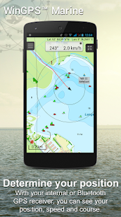
WinGPS™ Marine: Navigation on board using your tablet or smartphone.
With this app, route and waypoint navigation on nautical charts is easier than ever. With weather predictions and AIS you can create extra safety on board because you know what's coming.
This app is developed for navigation from sailing and motor yachts, to sloops and kayaks. Did you charter a boat, are you going diving or sport fishing? Then also use this app!
HIGHLIGHTS
• Navigate on high quality water charts.
• North-up GPS follow mode.
• Very user friendly way to create and edit waypoint and routes.
• Easy management of tracks, charts, routes and waypoints.
• Worldwide wind, air pressure, and rainfall prediction.
• Independent navigation system thanks to the internal GPS of your tablet or smartphone.
• Connect AIS and GPS wirelessly using a WIFI or Bluetooth connection.
• Avoid collisions with the velocity vectors of AIS vessels around you.
• The man-overboard button marks the position of the lost crew member and helps you find it.
IN-APP PURCHASE
After purchasing WinGPS™ Marine you unlock the full features of the app. Check out the various possibilities on www.wingpsmarine.com.
When first installing the app you will get the Lite version of WinGPS™ Marine.
This version is limited functionality. With your GPS (internal or bluetooth) you get the SOG and COG and you will see the current position on your screen.
WinGPS™ Marine is the navigation app that allows true marine navigation on your Android device. In this app you can use the digital nautical charts for route planning with GPS via WIFI or bluetooth. You can also get data from AIS, GRIB meteo and record the tracks you have sailed. Use the built-in "timebar" to see the developments of the wind, rain, air pressure and AIS plotted on the screen.
The WinGPS™ Marine Plus upgrade provides you all the best of the Marine Apps. This advanced navigation app helps you plan routes under every condition. You can connect your board system using a wireless connection and use all this data to your advantage. The worldwide tidal & current predictions can be displayed in the data plotter, and on your chart screen.
CHART COVERAGE & INSTALLING CHARTS
When starting WinGPS™ Marine you will automatically use the free charts of OpenStreetMap. You can also download the free world chart via the chart manager.
For safe navigation you can best use digital water charts which Stentec offers you in the Google Play ™ store or in the online shop on www.stentec.com. When purchasing a chart you get a license code which you can activate on 2 separate machines (with a third backup activation). This enables you to use the charts on your Android device as well as on your laptop/PC.
If you purchased charts using Google Play™, you need to connect them with your account to use them in WinGPS™ Marine. You can do this 2 hours after purchase. If you purchased the charts via www.stentec.com, this will go automatically.
If you login in WinGPS™ Marine, you can select your DKW chart licenses in the chart manager to download and update for use in the app. The charts are immediately ready for use!
Examples of DKW Charts are: Stentec’s DKW charts, UKHO, BSH, Imray, Delius Klasing and the DKW 1800 series with weekly BaZ update service.
On your PC you can download the free BSB charts of for example NOAA. After installation with the DKW Manager, you can copy these charts to your tablet. The easiest way to do this is with a USB cable.
Examples of NOAA/BSB charts are: United States, Brazil, New Zealand, and all charts you create with DKW Builder (scanned charts).
USER FEEDBACK
We are very interested in your experiences with this app and your suggestions so that we can use it to improve this app. If you got any suggestions, please send an e-mail to helpdesk@stentec.com.
WinGPS ™ marino: navegación a bordo de usar su tableta o teléfono inteligente.
Con esta aplicación, la ruta y la navegación waypoint en las cartas náuticas es más fácil que nunca. Con las predicciones meteorológicas y AIS puede crear mayor seguridad a bordo, porque usted sabe lo que viene.
Esta aplicación está desarrollada para la navegación de vela y motor yates, a balandras y kayaks. ¿Sabía usted alquilar un barco, vas buceo o pesca deportiva? Entonces también utilizar esta aplicación!
REFLEJOS
• Navegar en las cartas de agua de alta calidad.
• GPS Norte-up modo de seguir.
• Muy fácil de manera amigable para crear y editar waypoints y rutas.
• Fácil gestión de pistas, gráficos, rutas o puntos de interés.
• viento por todo el mundo, la presión del aire, y la predicción de lluvia.
• sistema de navegación independiente gracias al GPS interno de su tableta o teléfono inteligente.
• Conecte AIS y GPS de forma inalámbrica utilizando una conexión WiFi o Bluetooth.
• Evite las colisiones con los vectores de velocidad de las embarcaciones AIS a tu alrededor.
• El botón de hombre al agua marca la posición del miembro de la tripulación perdida y te ayuda a encontrar la misma.
IN-APP COMPRA
Después de comprar WinGPS ™ Marina de desbloquear todas las características de la aplicación. Echa un vistazo a las diversas posibilidades en www.wingpsmarine.com.
Al instalar primero la aplicación obtendrá la versión Lite de WinGPS ™ Marina.
Esta versión es una funcionalidad limitada. Con su GPS (interno o bluetooth) se obtiene el SOG y COG y verá la posición actual en la pantalla.
WinGPS ™ Marine es la aplicación de navegación que permite la verdadera navegación marítima en su dispositivo Android. En esta aplicación se puede utilizar las cartas náuticas digitales para la planificación de rutas con GPS a través de WiFi o Bluetooth. También puede obtener datos de AIS, GRIB meteo y grabar las pistas que ha navegado. Utilice el built-in "barra de tiempo" para ver la evolución del viento, la lluvia, la presión del aire y AIS traza en la pantalla.
La actualización WinGPS ™ Marina Plus le ofrece todo lo mejor de las aplicaciones de Marina. Esta aplicación de navegación avanzada le ayuda a planificar rutas en todas las condiciones. Puede conectar el sistema de caja mediante una conexión inalámbrica y el uso de todos estos datos a su ventaja. Las predicciones de mareas y corrientes de todo el mundo se pueden mostrar en el plotter de datos, y en la pantalla gráfica.
TABLA DE COBERTURA Y CARTAS INSTALACIÓN
Al iniciar WinGPS ™ marina que utilizará automáticamente las listas gratuitas de OpenStreetMap. También puede descargar el gráfico mundo libre a través del gestor gráfico.
Para una navegación segura puede utilizar mejor los gráficos de agua digitales que Stentec le ofrece en la tienda Google Play ™ o en la tienda en línea en www.stentec.com. Al comprar un gráfico a obtener un código de licencia que se puede activar en 2 máquinas separadas (con una tercera activación de copia de seguridad). Esto le permite utilizar las listas de éxitos en su dispositivo Android, así como en su ordenador portátil / PC.
Si ha adquirido gráficos utilizando Google Play ™, tiene que conectarlos con su cuenta de utilizarlos en WinGPS ™ Marina. Usted puede hacer esto 2 horas después de la compra. Si ha adquirido a través de las listas de éxitos www.stentec.com, esto irá automáticamente.
Si te registras en WinGPS ™ marina, puede seleccionar sus licencias tabla de DKW en el gestor gráfico de descargar y actualizar para su uso en la aplicación. Los gráficos son inmediatamente listo para su uso!
Ejemplos de Gráficos DKW son: gráficos DKW de Stentec, UKHO, BSH, Imray, Delius Klasing y la serie DKW 1800 con servicio semanal de actualización Baz.
En el PC se puede descargar las listas gratuitas de BSB por ejemplo NOAA. Después de la instalación con el Administrador de DKW, puede copiar estas tablas para su tableta. La forma más fácil de hacerlo es con un cable USB.
Ejemplos gráficos de NOAA / BSB de son: Estados Unidos, Brasil, Nueva Zelanda, y todas las cartas que cree DKW Builder (cartas escaneadas) con.
COMENTARIOS DE USUARIO
Estamos muy interesados en sus experiencias con esta aplicación y sus sugerencias para que podamos utilizar para mejorar esta aplicación. Si tienes alguna sugerencia, por favor envíe un e-mail a helpdesk@stentec.com.
