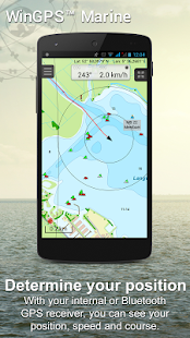
WinGPS™ Marine: Navigation on board using your tablet or smartphone.
With this app, route and waypoint navigation on nautical charts is easier than ever. With weather predictions and AIS you can create extra safety on board because you know what's coming.
This app is developed for navigation from sailing and motor yachts, to sloops and kayaks. Did you charter a boat, are you going diving or sport fishing? Then also use this app!
HIGHLIGHTS
• Navigate on high quality water charts.
• North-up GPS follow mode.
• Very user friendly way to create and edit waypoint and routes.
• Easy management of tracks, charts, routes and waypoints.
• Worldwide wind, air pressure, and rainfall prediction.
• Independent navigation system thanks to the internal GPS of your tablet or smartphone.
• Connect AIS and GPS wirelessly using a WIFI or Bluetooth connection.
• Avoid collisions with the velocity vectors of AIS vessels around you.
• The man-overboard button marks the position of the lost crew member and helps you find it.
IN-APP PURCHASE
After purchasing WinGPS™ Marine you unlock the full features of the app. Check out the various possibilities on www.wingpsmarine.com.
When first installing the app you will get the Lite version of WinGPS™ Marine.
This version is limited functionality. With your GPS (internal or bluetooth) you get the SOG and COG and you will see the current position on your screen.
WinGPS™ Marine is the navigation app that allows true marine navigation on your Android device. In this app you can use the digital nautical charts for route planning with GPS via WIFI or bluetooth. You can also get data from AIS, GRIB meteo and record the tracks you have sailed. Use the built-in "timebar" to see the developments of the wind, rain, air pressure and AIS plotted on the screen.
The WinGPS™ Marine Plus upgrade provides you all the best of the Marine Apps. This advanced navigation app helps you plan routes under every condition. You can connect your board system using a wireless connection and use all this data to your advantage. The worldwide tidal & current predictions can be displayed in the data plotter, and on your chart screen.
CHART COVERAGE & INSTALLING CHARTS
When starting WinGPS™ Marine you will automatically use the free charts of OpenStreetMap. You can also download the free world chart via the chart manager.
For safe navigation you can best use digital water charts which Stentec offers you in the Google Play ™ store or in the online shop on www.stentec.com. When purchasing a chart you get a license code which you can activate on 2 separate machines (with a third backup activation). This enables you to use the charts on your Android device as well as on your laptop/PC.
If you purchased charts using Google Play™, you need to connect them with your account to use them in WinGPS™ Marine. You can do this 2 hours after purchase. If you purchased the charts via www.stentec.com, this will go automatically.
If you login in WinGPS™ Marine, you can select your DKW chart licenses in the chart manager to download and update for use in the app. The charts are immediately ready for use!
Examples of DKW Charts are: Stentec’s DKW charts, UKHO, BSH, Imray, Delius Klasing and the DKW 1800 series with weekly BaZ update service.
On your PC you can download the free BSB charts of for example NOAA. After installation with the DKW Manager, you can copy these charts to your tablet. The easiest way to do this is with a USB cable.
Examples of NOAA/BSB charts are: United States, Brazil, New Zealand, and all charts you create with DKW Builder (scanned charts).
USER FEEDBACK
We are very interested in your experiences with this app and your suggestions so that we can use it to improve this app. If you got any suggestions, please send an e-mail to helpdesk@stentec.com.
WinGPS ™ 해양 : 태블릿 또는 스마트 폰을 사용하여 보드에 탐색.
이 응용 프로그램과 함께, 해상 차트에 경로 및 웨이 포인트 탐색은 그 어느 때보 다 쉬워졌습니다. 당신은 무슨 일이 일어날 지 알고 있기 때문에 기상 예측 및 AIS를 사용하면 보드에 별도의 안전을 만들 수 있습니다.
이 응용 프로그램은 슬루프와 카약에, 요트와 모터 요트에서 탐색을 위해 개발되고있다. 당신 전세 보트나요 당신은 다이빙이나 스포츠 낚시를가는거야? 그런 다음이 응용 프로그램을 사용!
하이라이트
• 고품질의 물을 차트에 이동합니다.
• 북한 업 GPS 모드를 따릅니다.
• 매우 사용자 편집 웨이 포인트와 경로 등을 만들 수있는 쉬운 방법.
• 트랙, 차트, 경로 및 웨이 포인트의 쉬운 관리.
• 전세계 바람, 기압, 강수량 예측.
• 태블릿 또는 스마트 폰의 내장 GPS에 독립적 인 네비게이션 시스템 감사합니다.
• 연결 AIS 및 GPS 무선 와이파이 또는 Bluetooth 연결을 사용.
• 주변 AIS는 선박의 속도 벡터와의 충돌을 피하십시오.
• 사람이 배 밖으로 버튼을 잃어버린 승무원의 위치를 표시하고 당신이 그것을 찾을 수 있습니다.
구매 - 앱에있는
WinGPS ™ 해양를 구입 한 후에는 응용 프로그램의 전체 기능의 잠금을 해제. www.wingpsmarine.com에 다양한 가능성을 확인하십시오.
먼저 응용 프로그램을 설치할 때 WinGPS ™ 해양의 라이트 버전을 얻을 것이다.
이 버전은 제한된 기능입니다. GPS를 통해 (내부 또는 블루투스) 당신은 SOG와 COG을 얻을 당신은 당신의 화면에 현재 위치가 표시됩니다.
WinGPS ™ 해양은 안드로이드 장치에 진정한 해양 탐색 할 수있는 탐색 응용 프로그램입니다. 이 응용 프로그램에서 당신은 와이파이 또는 블루투스를 통해 GPS와 노선 계획을위한 디지털 항해 차트를 사용할 수 있습니다. 또한 AIS, GRIB 기상 관측 데이터를 얻을 당신이 항해 한 트랙을 녹음 할 수 있습니다. 바람, 비, 공기압의 개발을보고 내장 "TimeBar가"를 사용하고 AIS는 스크린에 그려.
WinGPS ™ 마린 플러스 업그레이드는 당신에게 해양 애플리케이션의 모든 최선을 제공합니다. 이 고급 네비게이션 응용 프로그램은 모든 조건 하에서 경로를 계획하는 데 도움이됩니다. 당신은 무선 연결을 사용하여 보드 시스템을 연결하고 당신의 이점에이 모든 데이터를 사용할 수 있습니다. 전 세계적으로 조류 및 현재의 예측은 데이터 플로터에 표시하고, 차트 화면에서 할 수 있습니다.
도표 적용 범위 설치하기 도표
WinGPS을 시작할 때 ™ 해양은 자동 OpenStreetMap에의 자유로운 차트를 사용합니다. 또한 차트 매니저를 통해 자유 세계 차트를 다운로드 할 수 있습니다.
안전한 항해를 들어, 당신은 최고의 Stentec은 구글 플레이 ™ 저장소 또는 www.stentec.com의 온라인 상점에서 당신을 제공하는 디지털 물 차트를 사용할 수 있습니다. 차트를 구입할 때 당신은 (세 번째 백업 활성화와) 당신이 별도의 시스템에 활성화 할 수있는 라이센스 코드를 얻을. 이것은 당신의 안드로이드 장치에뿐만 아니라 노트북 / PC의 차트를 사용 할 수 있습니다.
당신이 구글 플레이 ™를 사용하여 차트를 구입 한 경우, 당신은 WinGPS ™ 해양에서 사용하는 계정과 그들을 연결해야합니다. 당신은 구입 후이 2 시간 할 수 있습니다. 당신이 www.stentec.com를 통해 차트를 구입 한 경우,이 자동으로 이동합니다.
당신이 WinGPS ™ 해양에 로그인 할 경우, 다운로드 및 응용 프로그램에 사용하기 위해 업데이트 할 차트 관리자에 DKW 차트 라이센스를 선택할 수 있습니다. 차트는 사용 즉시 준비!
DKW 차트의 예는 다음과 같습니다 Stentec의 DKW 차트, UKHO, BSH, Imray, 딜리 어스 Klasing 및 주간 바즈 업데이트 서비스와 DKW 1800 시리즈.
당신의 PC에 당신은 예를 들어 NOAA에 대한의 무료 BSB 차트를 다운로드 할 수 있습니다. DKW Manager를 설치 한 후, 당신은 당신의 태블릿에이 차트를 복사 할 수 있습니다. 이 작업을 수행하는 가장 쉬운 방법은 USB 케이블입니다.
NOAA / BSB 차트의 예는 다음과 같다 : 미국, 브라질, 뉴질랜드, 모든 차트는 DKW 빌더 (스캔 차트)를 만들 수 있습니다.
사용자 피드백
우리는이 응용 프로그램을 개선하기 위해 사용할 수 있도록 우리는이 응용 프로그램과 함께 당신의 경험과 제안에 매우 관심이 있습니다. 당신이 어떤 제안을 가지고있는 경우, helpdesk@stentec.com으로 이메일을 보내 주시기 바랍니다.
