
WinGPS™ Marine: Navigation on board using your tablet or smartphone.
With this app, route and waypoint navigation on nautical charts is easier than ever. With weather predictions and AIS you can create extra safety on board because you know what's coming.
This app is developed for navigation from sailing and motor yachts, to sloops and kayaks. Did you charter a boat, are you going diving or sport fishing? Then also use this app!
HIGHLIGHTS
• Navigate on high quality water charts.
• North-up GPS follow mode.
• Very user friendly way to create and edit waypoint and routes.
• Easy management of tracks, charts, routes and waypoints.
• Worldwide wind, air pressure, and rainfall prediction.
• Independent navigation system thanks to the internal GPS of your tablet or smartphone.
• Connect AIS and GPS wirelessly using a WIFI or Bluetooth connection.
• Avoid collisions with the velocity vectors of AIS vessels around you.
• The man-overboard button marks the position of the lost crew member and helps you find it.
IN-APP PURCHASE
After purchasing WinGPS™ Marine you unlock the full features of the app. Check out the various possibilities on www.wingpsmarine.com.
When first installing the app you will get the Lite version of WinGPS™ Marine.
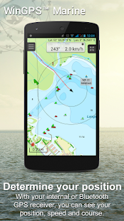
This version is limited functionality. With your GPS (internal or bluetooth) you get the SOG and COG and you will see the current position on your screen.
WinGPS™ Marine is the navigation app that allows true marine navigation on your Android device. In this app you can use the digital nautical charts for route planning with GPS via WIFI or bluetooth. You can also get data from AIS, GRIB meteo and record the tracks you have sailed. Use the built-in "timebar" to see the developments of the wind, rain, air pressure and AIS plotted on the screen.
The WinGPS™ Marine Plus upgrade provides you all the best of the Marine Apps. This advanced navigation app helps you plan routes under every condition. You can connect your board system using a wireless connection and use all this data to your advantage. The worldwide tidal & current predictions can be displayed in the data plotter, and on your chart screen.
CHART COVERAGE & INSTALLING CHARTS
When starting WinGPS™ Marine you will automatically use the free charts of OpenStreetMap. You can also download the free world chart via the chart manager.
For safe navigation you can best use digital water charts which Stentec offers you in the Google Play ™ store or in the online shop on www.stentec.com. When purchasing a chart you get a license code which you can activate on 2 separate machines (with a third backup activation). This enables you to use the charts on your Android device as well as on your laptop/PC.
If you purchased charts using Google Play™, you need to connect them with your account to use them in WinGPS™ Marine. You can do this 2 hours after purchase. If you purchased the charts via www.stentec.com, this will go automatically.
If you login in WinGPS™ Marine, you can select your DKW chart licenses in the chart manager to download and update for use in the app. The charts are immediately ready for use!
Examples of DKW Charts are: Stentec’s DKW charts, UKHO, BSH, Imray, Delius Klasing and the DKW 1800 series with weekly BaZ update service.
On your PC you can download the free BSB charts of for example NOAA. After installation with the DKW Manager, you can copy these charts to your tablet. The easiest way to do this is with a USB cable.
Examples of NOAA/BSB charts are: United States, Brazil, New Zealand, and all charts you create with DKW Builder (scanned charts).
USER FEEDBACK
We are very interested in your experiences with this app and your suggestions so that we can use it to improve this app. If you got any suggestions, please send an e-mail to helpdesk@stentec.com.
WinGPS ™ Marine: navigazione a bordo utilizzando il tuo tablet o smartphone.
Con questa applicazione, percorso e la navigazione waypoint sulle carte nautiche è più facile che mai. Con le previsioni meteo e AIS è possibile creare una maggiore sicurezza a bordo perché non si sa cosa sta per succedere.
Questa applicazione è stata sviluppata per la navigazione da vela e yacht a motore, a sloop e kayak. Ti è noleggiare una barca, stai andando immersioni o pesca sportiva? Quindi utilizzare anche questa app!
METTE IN EVIDENZA
• Spostarsi sui grafici di acqua di alta qualità.
• Nord-up GPS modalità seguire.
• Molto facile modo amichevole per creare e modificare waypoint e rotte.
• Facile gestione dei brani, grafici, rotte e waypoint.
• vento in tutto il mondo, la pressione dell'aria, e la previsione delle precipitazioni.
• sistema di navigazione indipendente grazie al GPS interno del tuo tablet o smartphone.
• Collegare AIS e GPS in modalità wireless utilizzando una connessione WiFi o Bluetooth.
• Evitate le collisioni con i vettori di velocità delle imbarcazioni AIS intorno a voi.
• Il pulsante uomo a mare indica la posizione del membro dell'equipaggio perso e aiuta a trovarlo.
ACQUISTO IN APP
Dopo l'acquisto WinGPS ™ Marine si sbloccano tutte le funzionalità di app. Scopri le varie possibilità di www.wingpsmarine.com.
La prima volta che si installa l'applicazione si otterrà la versione Lite di WinGPS ™ Marine.
Questa versione è una funzionalità limitata. Con il GPS (interno o Bluetooth) si ottiene la SOG e COG e vedrete la posizione corrente sullo schermo.
WinGPS ™ Marine è l'applicazione di navigazione che permette di allineare la navigazione marina sul proprio dispositivo Android. In questa applicazione è possibile utilizzare le carte nautiche digitali per la pianificazione del percorso con GPS tramite WiFi o Bluetooth. È inoltre possibile ottenere i dati di AIS, GRIB meteo e registrare le tracce che hai navigato. Utilizzare il built-in "timebar" per vedere gli sviluppi del vento, la pioggia, la pressione dell'aria e AIS tracciata sullo schermo.
L'aggiornamento WinGPS ™ Marine Plus offre tutto il meglio delle applicazioni marine. Questa applicazione di navigazione avanzata consente di pianificare itinerari in ogni condizione. È possibile collegare il sistema di bordo utilizzando una connessione senza fili e utilizzare tutti questi dati a vostro vantaggio. Le previsioni di marea e di corrente in tutto il mondo possono essere visualizzati nel plotter di dati, e sullo schermo grafico.
TABELLA DI COPERTURA & ALBERI INSTALLAZIONE
Quando si avvia WinGPS ™ Marine si utilizza automaticamente le carte gratuite di OpenStreetMap. È anche possibile scaricare il grafico mondo libero attraverso il gestore grafico.
Per la sicurezza della navigazione è possibile utilizzare meglio i grafici acqua digitali che Stentec vi offre in negozio Google Play ™ o nel negozio online su www.stentec.com. Al momento dell'acquisto di un grafico si ottiene un codice di licenza, che è possibile attivare su 2 macchine separate (con un terzo intervento di backup). Ciò consente di utilizzare i grafici sul proprio dispositivo Android, così come sul vostro laptop / PC.
Se hai acquistato grafici utilizzando Google Play ™, è necessario collegare loro con il tuo account di utilizzarli in WinGPS ™ Marine. Si può fare questo 2 ore dopo l'acquisto. Se avete acquistato le classifiche via www.stentec.com, questo andrà automaticamente.
Se si effettua il login in WinGPS ™ Marine, è possibile selezionare i DKW licenze grafico nel gestore grafico per scaricare e aggiornare per l'uso in app. I grafici sono subito pronti per l'uso!
Esempi di DKW grafici sono: i grafici DKW di Stentec, UKHO, BSH, Imray, Delius Klasing e la serie DKW 1800 con servizio di aggiornamento BaZ settimanale.
Sul PC è possibile scaricare i BSB schemi gratuiti di per esempio NOAA. Dopo l'installazione con il Gestore DKW, è possibile copiare queste tabelle per il tablet. Il modo più semplice per farlo è con un cavo USB.
Esempi di tabelle NOAA / BSB sono: Stati Uniti, Brasile, Nuova Zelanda, e tutti i grafici creati con DKW Builder (grafici digitalizzati).
Il feedback degli utenti
Siamo molto interessati alle vostre esperienze con questa applicazione e vostri suggerimenti in modo che possiamo utilizzare per migliorare questa applicazione. Se hai dei suggerimenti, si prega di inviare una e-mail a helpdesk@stentec.com.
