The Memory-Map app turns your phone or tablet into a full-featured Outdoor GPS or Marine Chart Plotter, and allows you to navigate with Ordnance Survey Topo maps, 4WD maps or Marine charts, even without a wireless internet signal.
Maps are downloaded on-the-fly and can be pre-loaded so that they can be used offline. Once the app and maps are loaded to the phone or tablet, cellular network coverage or internet connection is not required for real time GPS navigation.
The Memory-Map app can be used as a standalone GPS navigator, but it can also be used in conjunction with the Windows PC app (free download) for planning, printing and loading up maps, waypoints and routes to the phone/tablet.
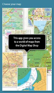
Memory-Map includes free access to 1:250,000 scale topographic maps and many other free maps around the world. More detailed maps are available for download and purchase with a free try-before-you-buy, time-limited demo option. Available maps include Ordnance Survey, Hema, USGS quads, NOAA, British Admiralty, and DeLorme. Maps can be used on your PC as well as your phone and tablet. The Cloud Sync feature allows you to keep the overlay data consistent on all your devices.
Features include:
Access a vast range of Worldwide maps and charts.
Automatically downloads a free map of your current location
Create and edit marks and routes.
Import and export marks, routes and tracks in the open GPX format
Display; Position, Course, Speed, Heading, Altitude and averages
Position coordinates include Lat/Long, UTM and GB Grid
Units displayed in Statute, Nautical or Metric
Support for GPS and Compass sensors, where available.
Placename index, can be used offline.
Moving map, lock GPS position and automatically scroll the map
Records breadcrumb trail / tracklogs.
Share position marks or tracklogs as GPX files
Proximity Alarm
Full marine instrumentation features, with AIS, DSC and Anchor alarm
NMEA data interface via WiFi or Bluetooth
AIS collision alarm, with adjustable thresholds for Class A and Class B targets
Display Alarm notifications and Nav data on Android Wear watch
"Verdict: The Memory-Map App is a truly excellent, competent product, representing real value for money. It's straightforward to use, with just enough preference settings and options to describe it as customizable. Route-creation and route-following are ridiculously easy to set up, yet provide a tremendous range of route data. You can also import and export GPX files (via email). A really strong product at this price point." Andrew Knight, Yacht Arabella blog
"After buying about 6 navigational applications for my tablet I finally got one that really works the way it should. I now have a handheld version of my sailboat's navigation system. I am very happy with this app and would recommend it to any avid sailor"
"I've tried all the mapping/tracking applications I can find and I rate this best. The 1:25k scale is essential for walkers and the ability to create a route at home or to log it (recording your time & distance etc) as you go along is superb. I like the direction indicator to show where you are heading on the map, the ability to save, describe and name tracks is neat. It's easy to slide the map about from your current position to see where you are heading next, the zooming in and out facility is good. I found it reasonably easy to learn how to use."
"This is not a cheap navigation program, it is a professional tool for viewing raster maps. And for this purpose, it is excellent. For viewing topo maps, this is the best software and hardware combination for the job, this alone was my reason to get an Android tablet, and it was the right decision."
该内存映射应用程序将您的手机或平板电脑变成一个全功能的GPS户外或海军海图,并允许您与军械测量局地图地形,四驱地图或海图导航,即使没有无线网络信号。
地图被下载在即时和可预加载的,以便它们可以离线使用。一旦应用程序和地图下载到手机或平板电脑,不需要实时GPS导航蜂窝网络或Internet连接。
该内存映射应用程序可以作为一个独立的GPS导航仪,但它也可以与Windows PC应用程序(免费下载)进行策划,印刷和加载了地图,航点和路线的手机/平板电脑一起使用。
内存映射包含了可以免费使用:全球约25万比例尺地形图和其他许多免费的地图。更详细的地图可供下载和购买的免费试穿之前,你买,有时间限制的演示选项。可用的地图包括地形测量局,喝骂,USGS四边形,诺阿,英国海军和德洛姆。地图可以将您的PC以及手机和平板电脑上使用。云同步功能可让您保持叠加数据在所有设备上保持一致。
其特点包括:
进入广阔的全球范围内的地图和图表。
自动下载您当前所在位置的免费地图
创建和编辑标记和路线。
进出口标志,在打开的GPX格式的路线和轨迹
显示;位置,航向,航速,航向,高度及均线
位置坐标包括纬度/经度,UTM和GB网格
按规程,航海或公制单位显示
支持GPS和指南针传感器,如果有的话。
地名索引,可脱机使用。
移动地图,锁定GPS位置,并自动滚动地图
记录浏览路径/ tracklogs。
分享位置标记或tracklogs为GPX文件
接近警报
全部船用仪表功能,具有AIS,DSC和锚报警
通过WiFi或蓝牙NMEA数据接口
AIS碰撞报警,符合A类可调节阈值和B类目标
显示报警通知和导航数据在Android Wear手表
“判决:内存地图应用程序是一个真正优秀,称职的产品,代表真正物超所值很容易使用,只有足够的首选项设置和选项,将其描述为定制的路线创造和航线以下是可笑容易。成立的,但提供路由数据的一个巨大的范围。您也可以导入和导出GPX文件(通过电子邮件)。一个真正强大的产品在这个价位上。“安德鲁·奈特,游艇阿拉贝拉博客
“买约6导航应用为我的平板电脑后,我终于得到了一个真正的作品应该。现在我有我的帆船的导航系统的掌机版的方式。我很高兴有这个程序,并会推荐给任何狂热的水手”
“我已经尝试了所有的绘图/跟踪应用可以找我,我这个打分的最佳1:25K规模为步行者和创造在家里或记录它的路由能力必不可少的(记录您的时间和距离等)当你走是一流的。我喜欢的方向指示灯,显示你在哪里在地图上的标题,有能力保存,描述和名称跟踪整洁,很容易对从当前位置在地图上滑动,看你在哪里标题旁边的放大和缩小设施是不错的。我发现它相当容易学会如何使用。“
“这不是一个便宜的导航程序,它可用于查看栅格地图的专业工具。并为此目的,它是优秀的。要查看地形图,这是这项工作的最好的软件和硬件的结合,这本身就是我的理由让Android平板电脑,这是一个正确的决定。“
