The Memory-Map app turns your phone or tablet into a full-featured Outdoor GPS or Marine Chart Plotter, and allows you to navigate with Ordnance Survey Topo maps, 4WD maps or Marine charts, even without a wireless internet signal.
Maps are downloaded on-the-fly and can be pre-loaded so that they can be used offline. Once the app and maps are loaded to the phone or tablet, cellular network coverage or internet connection is not required for real time GPS navigation.
The Memory-Map app can be used as a standalone GPS navigator, but it can also be used in conjunction with the Windows PC app (free download) for planning, printing and loading up maps, waypoints and routes to the phone/tablet.
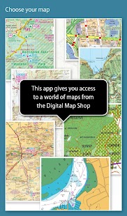
Memory-Map includes free access to 1:250,000 scale topographic maps and many other free maps around the world. More detailed maps are available for download and purchase with a free try-before-you-buy, time-limited demo option. Available maps include Ordnance Survey, Hema, USGS quads, NOAA, British Admiralty, and DeLorme. Maps can be used on your PC as well as your phone and tablet. The Cloud Sync feature allows you to keep the overlay data consistent on all your devices.
Features include:
Access a vast range of Worldwide maps and charts.
Automatically downloads a free map of your current location
Create and edit marks and routes.
Import and export marks, routes and tracks in the open GPX format
Display; Position, Course, Speed, Heading, Altitude and averages
Position coordinates include Lat/Long, UTM and GB Grid
Units displayed in Statute, Nautical or Metric
Support for GPS and Compass sensors, where available.
Placename index, can be used offline.
Moving map, lock GPS position and automatically scroll the map
Records breadcrumb trail / tracklogs.
Share position marks or tracklogs as GPX files
Proximity Alarm
Full marine instrumentation features, with AIS, DSC and Anchor alarm
NMEA data interface via WiFi or Bluetooth
AIS collision alarm, with adjustable thresholds for Class A and Class B targets
Display Alarm notifications and Nav data on Android Wear watch
"Verdict: The Memory-Map App is a truly excellent, competent product, representing real value for money. It's straightforward to use, with just enough preference settings and options to describe it as customizable. Route-creation and route-following are ridiculously easy to set up, yet provide a tremendous range of route data. You can also import and export GPX files (via email). A really strong product at this price point." Andrew Knight, Yacht Arabella blog
"After buying about 6 navigational applications for my tablet I finally got one that really works the way it should. I now have a handheld version of my sailboat's navigation system. I am very happy with this app and would recommend it to any avid sailor"
"I've tried all the mapping/tracking applications I can find and I rate this best. The 1:25k scale is essential for walkers and the ability to create a route at home or to log it (recording your time & distance etc) as you go along is superb. I like the direction indicator to show where you are heading on the map, the ability to save, describe and name tracks is neat. It's easy to slide the map about from your current position to see where you are heading next, the zooming in and out facility is good. I found it reasonably easy to learn how to use."
"This is not a cheap navigation program, it is a professional tool for viewing raster maps. And for this purpose, it is excellent. For viewing topo maps, this is the best software and hardware combination for the job, this alone was my reason to get an Android tablet, and it was the right decision."
