The Memory-Map app turns your phone or tablet into a full-featured Outdoor GPS or Marine Chart Plotter, and allows you to navigate with Ordnance Survey Topo maps, 4WD maps or Marine charts, even without a wireless internet signal.
Maps are downloaded on-the-fly and can be pre-loaded so that they can be used offline. Once the app and maps are loaded to the phone or tablet, cellular network coverage or internet connection is not required for real time GPS navigation.
The Memory-Map app can be used as a standalone GPS navigator, but it can also be used in conjunction with the Windows PC app (free download) for planning, printing and loading up maps, waypoints and routes to the phone/tablet.
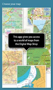
Memory-Map includes free access to 1:250,000 scale topographic maps and many other free maps around the world. More detailed maps are available for download and purchase with a free try-before-you-buy, time-limited demo option. Available maps include Ordnance Survey, Hema, USGS quads, NOAA, British Admiralty, and DeLorme. Maps can be used on your PC as well as your phone and tablet. The Cloud Sync feature allows you to keep the overlay data consistent on all your devices.
Features include:
Access a vast range of Worldwide maps and charts.
Automatically downloads a free map of your current location
Create and edit marks and routes.
Import and export marks, routes and tracks in the open GPX format
Display; Position, Course, Speed, Heading, Altitude and averages
Position coordinates include Lat/Long, UTM and GB Grid
Units displayed in Statute, Nautical or Metric
Support for GPS and Compass sensors, where available.
Placename index, can be used offline.
Moving map, lock GPS position and automatically scroll the map
Records breadcrumb trail / tracklogs.
Share position marks or tracklogs as GPX files
Proximity Alarm
Full marine instrumentation features, with AIS, DSC and Anchor alarm
NMEA data interface via WiFi or Bluetooth
AIS collision alarm, with adjustable thresholds for Class A and Class B targets
Display Alarm notifications and Nav data on Android Wear watch
"Verdict: The Memory-Map App is a truly excellent, competent product, representing real value for money. It's straightforward to use, with just enough preference settings and options to describe it as customizable. Route-creation and route-following are ridiculously easy to set up, yet provide a tremendous range of route data. You can also import and export GPX files (via email). A really strong product at this price point." Andrew Knight, Yacht Arabella blog
"After buying about 6 navigational applications for my tablet I finally got one that really works the way it should. I now have a handheld version of my sailboat's navigation system. I am very happy with this app and would recommend it to any avid sailor"
"I've tried all the mapping/tracking applications I can find and I rate this best. The 1:25k scale is essential for walkers and the ability to create a route at home or to log it (recording your time & distance etc) as you go along is superb. I like the direction indicator to show where you are heading on the map, the ability to save, describe and name tracks is neat. It's easy to slide the map about from your current position to see where you are heading next, the zooming in and out facility is good. I found it reasonably easy to learn how to use."
"This is not a cheap navigation program, it is a professional tool for viewing raster maps. And for this purpose, it is excellent. For viewing topo maps, this is the best software and hardware combination for the job, this alone was my reason to get an Android tablet, and it was the right decision."
メモリ・マップのアプリは、フル機能を備えた屋外GPSやマリンチャートプロッタにあなたの携帯電話またはタブレットをオンにし、あなたも無線インターネット信号なしで、陸地測量トポマップ、4WDマップやマリンチャートでナビゲートすることができます。
マップは、オンザフライでダウンロードされ、それらがオフラインで使用できるように事前にロードすることができます。アプリとマップは携帯電話やタブレットにロードされると、セルラーネットワークのカバレッジやインターネット接続がリアルタイムGPSナビゲーションのために必要とされていません。
メモリ・マップのアプリは、スタンドアロンGPSナビゲータとして使用することができますが、それはまた、携帯電話/タブレットの企画、印刷、ロードアップマップ、ウェイポイントとルートのためのWindows PCアプリ(無料ダウンロード)と組み合わせて使用することができます。
世界25万規模地形図および他の多くの無料の地図:メモリ-マップ1への無料アクセスが含まれています。より詳細なマップは無料のtry-前あなたは買い、期間限定のデモオプションを指定してダウンロードしてご購入いただけます。利用可能なマップは陸地測量、ヘマ、USGSクワッド、NOAA、英国海軍本部、およびデロームが含まれます。マップは、PCだけでなく、あなたの携帯電話とタブレット上で使用することができます。クラウド同期機能を使用すると、すべてのデバイス上で一貫性のオーバーレイデータを保持することができます。
機能は次のとおりです。
世界の地図やグラフの広大な範囲にアクセスします。
自動的にあなたの現在の場所の自由な地図をダウンロード
マークとルートを作成し、編集します。
オープンGPX形式でのインポートとエクスポートのマーク、ルートおよびトラック
表示;位置、コース、スピード、ヘディング、高度と平均値
位置座標は、緯度/経度、UTMおよびGBグリッドを含みます
規程、航海またはメトリックに表示ユニット
GPSとコンパスセンサーのサポート、利用できます。
地名インデックスは、オフラインで使用することができます。
マップ、ロックGPS位置を移動すると、自動的に地図をスクロール
レコードパンくずリスト/トラックログ。
GPXファイルとして共有位置マークやトラックログ
近接アラーム
AIS、DSCおよびアンカーアラーム付きフル海洋計測機器の機能、
WiFiまたはBluetooth経由でNMEAデータインターフェース
クラスAとクラスBのターゲットのための調整可能な閾値を有するAIS衝突警報、
Android Wear端末上で表示アラーム通知とナビゲーションデータ
"評決:メモリ・マップアプリはお金のための真の価値を表す、真に優れた、有能な製品です。これは、カスタマイズ可能なようにそれを記述するだけで十分な環境設定やオプションを使用して、使用することは簡単だルート作成やルート以下は途方もなく簡単です。セットアップ、まだルートデータの膨大な範囲を提供します。また、(電子メールを介して)GPXファイルをインポートおよびエクスポートすることができます。この価格で本当に強い製品を。」アンドリュー・ナイト、ヨットアラベラブログ
「私のタブレットのために約6のナビゲーションアプリケーションを購入した後、私はついに本当にそれは。私は今、私のヨットのナビゲーションシステムのハンドヘルドバージョンを持つ必要がありますように動作1つを得た。私はこのアプリと非常に満足しているし、任意の熱心な船員にそれをお勧めします」
「私は私が見つけることができるすべてのマッピング/トラッキング・アプリケーションを試してみたと私は、このベストを評価1:25Kスケールは(など、あなたの時間と距離を記録)歩行者や家庭でルートを作成したり、それをログに記録する能力に不可欠ですあなたが一緒に行くように素晴らしいです。私はあなたがマップ上に向かっている場合に、保存記述し、名前のトラック能力はきちんとであることを示すために方向指示器が好き。それはあなたがどこにあるか見るためにあなたの現在の位置から約地図をスライドするのは簡単です、次の見出しアウトでズームや施設が良いです。私が使用する方法を学習することが合理的に簡単に見つかりました。」
「これは、それがラスター地図を表示するためのプロフェッショナルツール安価なナビゲーションプログラムでされていない。この目的のために、それが優れている。地形マップを表示するために、このジョブのための最良のソフトウェアとハードウェアの組み合わせであり、これだけでは私の理由でしたAndroidタブレットを取得し、それは正しい判断でした。」
