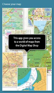
The Memory-Map app turns your phone or tablet into a full-featured Outdoor GPS or Marine Chart Plotter, and allows you to navigate with Ordnance Survey Topo maps, 4WD maps or Marine charts, even without a wireless internet signal.
Maps are downloaded on-the-fly and can be pre-loaded so that they can be used offline. Once the app and maps are loaded to the phone or tablet, cellular network coverage or internet connection is not required for real time GPS navigation.
The Memory-Map app can be used as a standalone GPS navigator, but it can also be used in conjunction with the Windows PC app (free download) for planning, printing and loading up maps, waypoints and routes to the phone/tablet.
Memory-Map includes free access to 1:250,000 scale topographic maps and many other free maps around the world. More detailed maps are available for download and purchase with a free try-before-you-buy, time-limited demo option. Available maps include Ordnance Survey, Hema, USGS quads, NOAA, British Admiralty, and DeLorme. Maps can be used on your PC as well as your phone and tablet. The Cloud Sync feature allows you to keep the overlay data consistent on all your devices.
Features include:
Access a vast range of Worldwide maps and charts.
Automatically downloads a free map of your current location
Create and edit marks and routes.
Import and export marks, routes and tracks in the open GPX format
Display; Position, Course, Speed, Heading, Altitude and averages
Position coordinates include Lat/Long, UTM and GB Grid
Units displayed in Statute, Nautical or Metric
Support for GPS and Compass sensors, where available.
Placename index, can be used offline.
Moving map, lock GPS position and automatically scroll the map
Records breadcrumb trail / tracklogs.
Share position marks or tracklogs as GPX files
Proximity Alarm
Full marine instrumentation features, with AIS, DSC and Anchor alarm
NMEA data interface via WiFi or Bluetooth
AIS collision alarm, with adjustable thresholds for Class A and Class B targets
Display Alarm notifications and Nav data on Android Wear watch
"Verdict: The Memory-Map App is a truly excellent, competent product, representing real value for money. It's straightforward to use, with just enough preference settings and options to describe it as customizable. Route-creation and route-following are ridiculously easy to set up, yet provide a tremendous range of route data. You can also import and export GPX files (via email). A really strong product at this price point." Andrew Knight, Yacht Arabella blog
"After buying about 6 navigational applications for my tablet I finally got one that really works the way it should. I now have a handheld version of my sailboat's navigation system. I am very happy with this app and would recommend it to any avid sailor"
"I've tried all the mapping/tracking applications I can find and I rate this best. The 1:25k scale is essential for walkers and the ability to create a route at home or to log it (recording your time & distance etc) as you go along is superb. I like the direction indicator to show where you are heading on the map, the ability to save, describe and name tracks is neat. It's easy to slide the map about from your current position to see where you are heading next, the zooming in and out facility is good. I found it reasonably easy to learn how to use."
"This is not a cheap navigation program, it is a professional tool for viewing raster maps. And for this purpose, it is excellent. For viewing topo maps, this is the best software and hardware combination for the job, this alone was my reason to get an Android tablet, and it was the right decision."
De Memory-Map app maakt van uw telefoon of tablet in een full-featured Outdoor GPS of Marine kaartplotter, en stelt u in staat om te navigeren met Ordnance Survey Topo kaarten, 4WD kaarten of Marine grafieken, zelfs zonder een draadloos internet signaal.
Kaarten worden gedownload op de vlucht en kan worden voorgeladen zodat ze offline kunnen worden gebruikt. Zodra de app en de kaarten zijn geladen naar de telefoon of tablet, wordt netwerkdekking of internet verbinding niet vereist voor real-time GPS-navigatie.
De Memory-Map app kan worden gebruikt als een standalone GPS-navigator, maar het kan ook gebruikt worden in combinatie met de Windows-pc app (gratis te downloaden) voor de planning, printen en het laden van kaarten, waypoints en routes naar de telefoon / tablet.
Memory-Map is inclusief gratis toegang tot de 1: 250.000 grootschalige topografische kaarten en vele andere gratis kaarten over de hele wereld. Meer gedetailleerde kaarten zijn beschikbaar om te downloaden en te kopen met een gratis try-before-you-buy, in de tijd beperkte demo optie. Beschikbare kaarten van onder Ordnance Survey, Hema, USGS quads, NOAA, Britse Admiraliteit, en DeLorme. Kaarten kunnen worden gebruikt op uw pc en uw telefoon en tablet. The Cloud Sync-functie kunt u de overlay-gegevens consequent op al je apparaten te houden.
Kenmerken omvatten:
Toegang tot een breed scala van Worldwide kaarten en grafieken.
Downloadt automatisch een gratis kaart van uw huidige locatie
Maak en merken en routes bewerken.
Import en export merken, routes en tracks in de open GPX-formaat
Display; Positie, koers, snelheid, koers, hoogte en gemiddelden
Positie coördinaten onder Lat / Long, UTM en GB Grid
Eenheden weergegeven in statuten, Nautical of Metric
Ondersteuning voor GPS en kompas sensoren, indien beschikbaar.
Placename index, kan offline worden gebruikt.
Bewegende kaart, slot GPS-positie en automatisch scrollen de kaart
Records broodkruimelspoor / tracklogs.
positie aandeel merken of tracklogs als GPX-bestanden
Proximity Alarm
Volledige marine instrumentatie functies, met AIS, DSC en Ankeralarm
NMEA data interface via WiFi of Bluetooth
AIS botsing alarm, met instelbare drempels voor klasse A en klasse B targets
Weergave Alarmmeldingen en Nav gegevens over Android Wear horloge
"Oordeel: The Memory-Map App is een werkelijk uitstekend, bekwaam product, wat neerkomt op reële waarde voor je geld Het is eenvoudig te gebruiken, met net genoeg voorkeursinstellingen en opties om het te beschrijven als aanpasbare Route-creatie en-route na zijn belachelijk makkelijk.. op te zetten, toch een enorm aantal routegegevens. U kunt ook importeren en exporteren GPX-bestanden (via e-mail). een heel sterk product voor deze prijs. " Andrew Knight, Yacht Arabella blog
"Na het kopen van ongeveer 6 navigatie-applicaties voor mijn tablet ik eindelijk een die echt werkt zoals het zou moeten. Ik heb nu een handheld versie van mijn zeilboot navigatiesysteem. Ik ben erg blij met deze app en zou het aanbevelen aan een fervent zeiler"
"Ik heb geprobeerd alle in kaart brengen / volgen programma's die ik kan vinden en ik prijs dit best De 1:. 25k schaal is essentieel voor wandelaars en de mogelijkheid om een route thuis of om het log te maken (het opslaan van uw tijd en afstand etc) als je verder gaat is fantastisch. ik hou van de richtingaanwijzer te laten zien waar u naar op de kaart, de mogelijkheid om op te slaan, te beschrijven en de naam tracks is netjes. het is gemakkelijk om de kaart over van uw huidige positie te schuiven om te zien waar je bent rubriek next, de in- en uitzoomen faciliteit is goed. ik vond het redelijk eenvoudig te leren hoe te gebruiken. "
"Dit is niet een goedkope navigatie-programma, is een professionele tool voor het bekijken van raster kaarten. En voor dit doel, het is uitstekend. Voor het bekijken van topo kaarten, dit is de beste software en hardware combinatie voor de baan, dit was alleen mijn verstand om een Android-tablet te krijgen, en het was de juiste beslissing. "
