The Memory-Map app turns your phone or tablet into a full-featured Outdoor GPS or Marine Chart Plotter, and allows you to navigate with Ordnance Survey Topo maps, 4WD maps or Marine charts, even without a wireless internet signal.
Maps are downloaded on-the-fly and can be pre-loaded so that they can be used offline. Once the app and maps are loaded to the phone or tablet, cellular network coverage or internet connection is not required for real time GPS navigation.
The Memory-Map app can be used as a standalone GPS navigator, but it can also be used in conjunction with the Windows PC app (free download) for planning, printing and loading up maps, waypoints and routes to the phone/tablet.
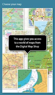
Memory-Map includes free access to 1:250,000 scale topographic maps and many other free maps around the world. More detailed maps are available for download and purchase with a free try-before-you-buy, time-limited demo option. Available maps include Ordnance Survey, Hema, USGS quads, NOAA, British Admiralty, and DeLorme. Maps can be used on your PC as well as your phone and tablet. The Cloud Sync feature allows you to keep the overlay data consistent on all your devices.
Features include:
Access a vast range of Worldwide maps and charts.
Automatically downloads a free map of your current location
Create and edit marks and routes.
Import and export marks, routes and tracks in the open GPX format
Display; Position, Course, Speed, Heading, Altitude and averages
Position coordinates include Lat/Long, UTM and GB Grid
Units displayed in Statute, Nautical or Metric
Support for GPS and Compass sensors, where available.
Placename index, can be used offline.
Moving map, lock GPS position and automatically scroll the map
Records breadcrumb trail / tracklogs.
Share position marks or tracklogs as GPX files
Proximity Alarm
Full marine instrumentation features, with AIS, DSC and Anchor alarm
NMEA data interface via WiFi or Bluetooth
AIS collision alarm, with adjustable thresholds for Class A and Class B targets
Display Alarm notifications and Nav data on Android Wear watch
"Verdict: The Memory-Map App is a truly excellent, competent product, representing real value for money. It's straightforward to use, with just enough preference settings and options to describe it as customizable. Route-creation and route-following are ridiculously easy to set up, yet provide a tremendous range of route data. You can also import and export GPX files (via email). A really strong product at this price point." Andrew Knight, Yacht Arabella blog
"After buying about 6 navigational applications for my tablet I finally got one that really works the way it should. I now have a handheld version of my sailboat's navigation system. I am very happy with this app and would recommend it to any avid sailor"
"I've tried all the mapping/tracking applications I can find and I rate this best. The 1:25k scale is essential for walkers and the ability to create a route at home or to log it (recording your time & distance etc) as you go along is superb. I like the direction indicator to show where you are heading on the map, the ability to save, describe and name tracks is neat. It's easy to slide the map about from your current position to see where you are heading next, the zooming in and out facility is good. I found it reasonably easy to learn how to use."
"This is not a cheap navigation program, it is a professional tool for viewing raster maps. And for this purpose, it is excellent. For viewing topo maps, this is the best software and hardware combination for the job, this alone was my reason to get an Android tablet, and it was the right decision."
La Memory-Map applicazione trasforma il tuo telefono o tablet in un plotter full-optional GPS esterna o Marine Grafico, e permette di navigare con le mappe Ordnance Survey Topo, mappe 4WD o di carte marine, anche senza un segnale wireless a internet.
Mappe vengono scaricate on-the-fly e può essere pre-caricato in modo che possano essere utilizzati offline. Una volta che l'applicazione e le mappe sono caricate al telefono o tablet, copertura della rete cellulare o connessione a Internet non è richiesto per la navigazione GPS in tempo reale.
L'applicazione Memory-Map può essere utilizzato come navigatore GPS stand-alone, ma può essere utilizzato anche in combinazione con l'applicazione PC Windows (download gratuito) per la pianificazione, la stampa e caricamento delle mappe su, waypoint e rotte per il telefono / tablet.
Memory-Map include l'accesso gratuito a 1: le mappe topografiche in scala 250.000 e molte altre mappe gratuite in tutto il mondo. le mappe più dettagliate sono disponibili per il download e l'acquisto con un libero try-before-you-buy, l'opzione demo limitata nel tempo. mappe disponibili includono Ordnance Survey, Hema, quad USGS, NOAA, britannico Ammiragliato, e DeLorme. Le mappe possono essere utilizzate sul vostro PC così come il telefono e tablet. La funzione di Cloud Sync permette di mantenere i dati di sovrapposizione coerente su tutti i dispositivi.
Le caratteristiche includono:
Accedere a una vasta gamma di mappe e grafici da tutto il mondo.
Scarica automaticamente una mappa gratuita della posizione corrente
Creare e modificare segni e percorsi.
Importazione ed esportazione di marchi, rotte e tracce in formato GPX aperto
Display; Posizione, rotta, velocità, direzione, altitudine e medie
coordinate della posizione includono Lat / Long, UTM e GB griglia
Unità visualizzate nello Statuto, nautiche o metriche
Il supporto per sensori GPS e bussola, se disponibili.
Indice toponimo, può essere utilizzato in linea.
mappa in movimento, la posizione GPS di blocco e automaticamente scorrere la mappa
sentiero Records breadcrumb / tracklogs.
marchi di posizione azionari o tracklogs come file GPX
allarme di prossimità
Caratteristiche strumentazione marina pieno, con AIS, DSC e l'allarme di ancoraggio
Interfaccia dati NMEA via WiFi o Bluetooth
Allarme collisione AIS, con soglie regolabili per Classe A e Classe B obiettivi
Visualizza notifiche di allarme e dati di navigazione di guardia Android Wear
"Verdetto: La Memory-Map App è un davvero eccellente, prodotto competente, che rappresenta un reale valore per il denaro E 'semplice da usare, con le impostazioni delle preferenze appena sufficiente e le opzioni per descrivere come personalizzabile Route-creazione e route-seguenti sono ridicolmente facile.. di istituire, per offrire una straordinaria gamma di dati del percorso. È inoltre possibile importare ed esportare file GPX (via email). un prodotto davvero forte a questo prezzo. " Andrew Knight, Yacht Arabella blog
"Dopo l'acquisto di circa 6 applicazioni di navigazione per la mia tavoletta ho finalmente ottenuto quello che funziona davvero il modo in cui dovrebbe. Ora ho una versione portatile del sistema di navigazione della mia barca a vela. Sono molto felice con questa applicazione e lo consiglio a qualsiasi velista appassionato"
"Ho provato tutte le applicazioni di mappatura / localizzazione posso trovare e considero questo miglior Il 1:. Scala 25k è essenziale per escursionisti e la capacità di creare un percorso a casa o per accedere esso (registrando il vostro tempo e distanza, ecc) come si va avanti è superba. mi piace l'indicatore di direzione per mostrare dove ci si sta muovendo sulla mappa, la possibilità di salvare, descrivere e nome traccia è pulito. e 'facile da far scorrere la mappa su dalla posizione attuale per vedere dove sei voce successiva, il zoom in e out struttura è buona. l'ho trovato abbastanza facile da imparare ad usare. "
"Questo non è un programma di navigazione a buon mercato, si tratta di uno strumento professionale per la visualizzazione delle mappe raster. E per questo scopo, è eccellente. Per la visualizzazione delle mappe topografiche, questo è il miglior software e hardware di combinazione per il lavoro, questo da solo era la mia ragione per ottenere un tablet Android, ed è stata la decisione giusta ".
