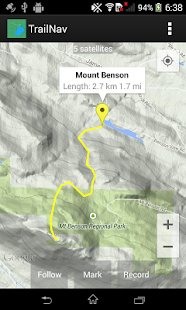
Find your way in the back country with this navigational tool. View maps, place markers, plan routes, view elevation and speed profiles, search for routes and markers, and record your movements across the land.
- Enable satellite tracking in Settings before starting
- To place a marker, tap on the map
- To plan a route, long press on the map, then tap along your route, then tap on the Record button
- While route planning, long press on the map to delete the last point
- To keep the map centred at your position, tap on the Follow button
- To keep your route pointing up, tap on the Follow button again
- To mark your current position, tap on the Follow button, wait for a satellite fix, then tap on the Mark button
- To record your movements, tap on the Follow button, then tap on the Record button
- To view a marker's information window, tap on the marker
- To rename or delete a marker, tap on the information window
- To find the flattest route, long press on the start point, then long press on the end point
- Android Wear notifications will be generated when satellite tracking or recording
- Marker detail screen will show geo tagged photos taken within 100 meters of the marker
- Graphs created using the Snowdon graphing library
- Automatic routing created using the A* search algorithm
このナビゲーションツールとバックカントリーにあなたの方法を見つけます。ビューマップ、場所マーカー、計画ルート、高度、速度プロファイルを表示、ルートやマーカーの探索、および土地を横切ってあなたの動きを記録。
- 開始する前に、[設定]の衛星追跡を有効にします
- 地図上をタップし、マーカーを配置するには
- 録音ボタンをタップし、あなたのルートに沿ってタップし、地図上にルート、長押しを計画するには
- 一方のルート計画は、マップ上の長押しは、最後のポイントを削除するには
- フォロー]ボタンをタップし、自分の位置を中心とする地図を維持するために、
- 再びフォローボタンをタップし、上向きのあなたのルートを維持するために
- その後、マークボタンをタップし、衛星の修正を待ち、フォローボタンをタップし、あなたの現在の位置をマークするには
- その後、録音ボタンをタップし、フォローボタンをタップし、あなたの動きを記録するには
- マーカーをタップし、マーカーの情報ウィンドウを表示するには
- 情報ウィンドウをタップ、マーカーの名前を変更または削除するには
- エンドポイント上で長押し、その後、開始点に最も平坦なルート、長押しを検索するには
- Android Wear通知は時衛星追跡や記録が生成されます
- マーカーの詳細画面では、ジオは写真がマーカーの100メートル以内に撮影されたタグ付けされた表示されます
- グラフはスノードンのグラフライブラリを使用して作成しました
- 自動ルーティングはA *探索アルゴリズムを使用して作成しました
