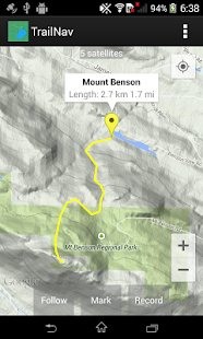
Find your way in the back country with this navigational tool. View maps, place markers, plan routes, view elevation and speed profiles, search for routes and markers, and record your movements across the land.
- Enable satellite tracking in Settings before starting
- To place a marker, tap on the map
- To plan a route, long press on the map, then tap along your route, then tap on the Record button
- While route planning, long press on the map to delete the last point
- To keep the map centred at your position, tap on the Follow button
- To keep your route pointing up, tap on the Follow button again
- To mark your current position, tap on the Follow button, wait for a satellite fix, then tap on the Mark button
- To record your movements, tap on the Follow button, then tap on the Record button
- To view a marker's information window, tap on the marker
- To rename or delete a marker, tap on the information window
- To find the flattest route, long press on the start point, then long press on the end point
- Android Wear notifications will be generated when satellite tracking or recording
- Marker detail screen will show geo tagged photos taken within 100 meters of the marker
- Graphs created using the Snowdon graphing library
- Automatic routing created using the A* search algorithm
Trova la tua strada nel paese indietro con questo strumento di navigazione. Visualizza mappe, segnaposti, pianificare itinerari, visualizzare profili altimetrici e di velocità, la ricerca di percorsi e pennarelli, e registrare i movimenti in tutto il paese.
- Attiva il monitoraggio via satellite in Impostazioni prima di iniziare
- Per inserire un marcatore, toccare sulla mappa
- Per pianificare un itinerario, premere a lungo sulla mappa, quindi tocca lungo il percorso, quindi toccare il pulsante Registra
- Durante la pianificazione del percorso, premere a lungo sulla mappa per cancellare l'ultimo punto
- Per mantenere la mappa centrata nella posizione, toccare il pulsante Segue
- Per mantenere il vostro percorso verso l'alto, toccare il pulsante Segue di nuovo
- Per contrassegnare la posizione corrente, toccare il pulsante Segue, attendere un fix satellitare, quindi toccare il pulsante Mark
- Per registrare i movimenti, toccare il pulsante Segue, quindi toccare il pulsante Registra
- Per visualizzare la finestra informazioni di un marcatore, toccare il marcatore
- Per rinominare o eliminare un marcatore, toccare la finestra delle informazioni
- Per trovare il percorso più piatta, premere a lungo sul punto di partenza, quindi premere a lungo il punto finale
- Indossare notifiche Android saranno generati quando il monitoraggio via satellite o la registrazione
- Schermo Marker dettaglio mostrerà geo tagged foto scattate a meno di 100 metri dal marcatore
- Grafici creato utilizzando la libreria grafica Snowdon
- Instradamento automatico creata usando l'A * algoritmo di ricerca
