No ads even in the free version!
Perfect for hiking, riding, cycling, running, skiing or orienteering
Premium topo maps
Use in-app purchases to subscribe to high-quality, special-purpose maps. Flexible offline mode and competitive pricing.
• OS OpenData (GB)
• IGN TOP25, TOP50, Cadastre, Satellite and Littoral (marine maps) (FR) http://www.frogsparks.com/mytrails/ign/
• Tour & Trail (Alpujarras, Axarquia, Costa Blanca, La Gomera, Lanzarote, La Palma, Madeira, Mallorca, Menorca, Sierra de Aracena, Tenerife)
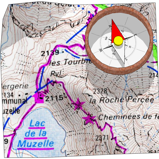
Full-screen trail map oriented with the built-in compass and GPS
Know exactly which direction you are going.
Uncluttered map area, with unobtrusive controls and a traditional scale with track duration and distance.
Hardware-accelerated map drawing allows smooth and snappy display even with tens of thousands of track points.
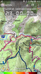
Stats
40+ stats to choose from!
Display them on a dedicated screen (including stats for multiple tracks at once), on the HUD overlaying the map or even on Android Wear.
Graphs
Freely define axes (over 30 combinations) to visualize your tracks, including elevation profiles, speed vs. time, etc.
Free online maps
Pick from many built-in online map sources (OpenStreetMap, Yahoo, Bing, Google and many other global and local providers).
Add more map sources using the configurable map sources (URL or WMS).
Only premium maps are guaranteed: we may be forced to remove access to any of the free maps if requested by the rights-holders; this is regardless of whether you are using the Pro or Free version.
Offline maps
Save battery and data charges.
The map displays instantaneously.
No need to use desktop-based tools to create offline maps, you can do it in MyTrails, in the background.
Record GPS tracks
Visualize your track at any time and analyse your course during or after the outdoor activity.
Display multiple colorized GPS tracks at once
Visualize your previous outings and those uploaded to GPS community sites, so that you always pick a great trail.
Visualize the key indicators of the track (altitude, speed, rate of ascent, slope, GPS accuracy, etc.) right on the map with a detailed legend.
Waypoints
Manually add waypoints to indicate memorable spots or upcoming turns.
Waypoints are automatically generated when getting directions or when you take a break.
Share and archive tracks
Share your tracks on My Trails, GPSies, UtagawaVTT and la-trace.com.
Download tracks shared by other users in your vicinity.
Gestures
Easily switch between active maps by swiping three fingers left to right in the map view.
Pull down the HUD with information on your speed and altitude by swiping three fingers down your screen.
Full tablet support
Plan your outing on a large-screen tablet, go out and have fun, and when you're back, view the track in full glory.
Use Dropbox to seamlessly synchronize between devices.
FAQ: http://www.frogsparks.com/faq/
Permissions: please see the FAQ
심지어는 무료 버전에는 광고가 없습니다!
하이킹, 승마, 자전거 타기, 달리기, 스키, 오리 엔티 어링을위한 완벽한
의
프리미엄 TOPO지도
고품질, 특수 목적지도에 가입 - 응용 프로그램 구매를 사용합니다. 유연한 오프라인 모드와 경쟁력있는 가격.
• OS OpenData (GB)
• IGN TOP25, TOP50, 지적, 위성 및 리토 랄 (해양지도) (FR) http://www.frogsparks.com/mytrails/ign/
• 투어 및 트레일 (Alpujarras의, Axarquia, 코스타 블랑카, 라 고 메라, 란 사로 테, 라 팔마, 마데이라, 마요르카, 메 노르 카, 시에라 드 레세나, 테 네리 페)
에
지향 전체 화면 트레일지도 내장 된 나침반과 GPS
정확히 당신이 가고있는 방향을 알고있다.
눈에 거슬리지 통제 및 추적 기간과 거리가 기존의 규모와 정리지도 지역.
하드웨어 가속지도 그리기 수만 추적 점의 수만으로 부드럽고 이따위로 표시 할 수 있습니다.
다운로드 통계
선택할 수있는 40 + 통계!
HUD는지도 또는 안드로이드 착용에 오버레이에, (한 번에 여러 트랙에 대한 통계를 포함) 전용 화면에 표시됩니다.
의
그래프
자유 자재 등 고도 프로파일을 포함하여 트랙, 시간 대 속도, 시각화 (30 조합을 통해) 축을 정의
다운로드 무료 온라인지도
많은 내장 된 온라인지도 소스 (OpenStreetMap의, 야후, 빙, 구글과 많은 다른 글로벌 지역 업체)에서 선택합니다.
구성지도 소스 (URL 또는 WMS)를 사용하여 더 많은지도 소스를 추가합니다.
프리미엄 맵은 보장된다 : 우리는 권리 보유자 요청할 경우 무료지도의 접근을 강제로 제거 할 수있다; 이 수에 관계없이 프로 또는 무료 버전을 사용하고 있는지 여부입니다.
의
오프라인지도
배터리와 데이터 요금을 저장합니다.
지도는 순간적으로 표시됩니다.
오프라인지도를 만들 데스크톱 기반 도구를 사용할 필요가, 당신은 백그라운드에서 MyTrails에서 할 수 있습니다.
다운로드 기록 GPS는 추적
언제든지 트랙을 시각화하고 야외 활동을하는 동안 또는 그 이후 코스를 분석 할 수 있습니다.
의
한 번에 여러 색상 화 된 GPS 트랙을 표시
당신은 항상 큰 흔적을 선택할 수 있도록, 이전 투어 및 GPS의 커뮤니티 사이트에 업로드하는 시각화.
트랙의 주요 지표를 시각화 (고도, 속도, 상승, 기울기, GPS 정확도 등의 비율)을 마우스 오른쪽 자세한 전설을 가진지도.
의
중간 점
수동으로 기억에 남는 점이나 앞으로 회전을 표시하는 웨이 포인트를 추가합니다.
당신이 휴식을 취할 때 방향을 받고하거나 중간 지점이 자동으로 생성됩니다.
의
공유 및 아카이브 트랙
나의 트레일에 당신의 흔적을 공유 GPSies, UtagawaVTT 및 라 trace.com.
하여 주변의 다른 사용자가 공유하는 트랙을 다운로드합니다.
의
제스처
쉽게지도 뷰에서 왼쪽에서 오른쪽으로 세 손가락을 강타해서 활동지도 전환.
화면 아래 세 손가락을 강타하여 속도와 고도에 대한 정보 HUD를 당깁니다.
다운로드 전체 태블릿 지원
대형 스크린 태블릿에 외출을 계획 나가서 재미를 가지고 있고, 당신이있을 때, 한창 트랙을 볼 수 있습니다.
원활 장치간에 동기화 드롭 박스를 사용합니다.
FAQ : http://www.frogsparks.com/faq/
권한 : FAQ를 참조하십시오
