No ads even in the free version!
Perfect for hiking, riding, cycling, running, skiing or orienteering
Premium topo maps
Use in-app purchases to subscribe to high-quality, special-purpose maps. Flexible offline mode and competitive pricing.
• OS OpenData (GB)
• IGN TOP25, TOP50, Cadastre, Satellite and Littoral (marine maps) (FR) http://www.frogsparks.com/mytrails/ign/
• Tour & Trail (Alpujarras, Axarquia, Costa Blanca, La Gomera, Lanzarote, La Palma, Madeira, Mallorca, Menorca, Sierra de Aracena, Tenerife)
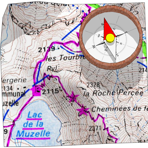
Full-screen trail map oriented with the built-in compass and GPS
Know exactly which direction you are going.
Uncluttered map area, with unobtrusive controls and a traditional scale with track duration and distance.
Hardware-accelerated map drawing allows smooth and snappy display even with tens of thousands of track points.
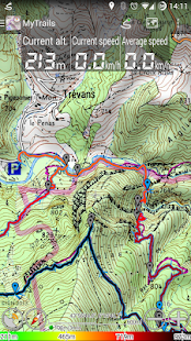
Stats
40+ stats to choose from!
Display them on a dedicated screen (including stats for multiple tracks at once), on the HUD overlaying the map or even on Android Wear.
Graphs
Freely define axes (over 30 combinations) to visualize your tracks, including elevation profiles, speed vs. time, etc.
Free online maps
Pick from many built-in online map sources (OpenStreetMap, Yahoo, Bing, Google and many other global and local providers).
Add more map sources using the configurable map sources (URL or WMS).
Only premium maps are guaranteed: we may be forced to remove access to any of the free maps if requested by the rights-holders; this is regardless of whether you are using the Pro or Free version.
Offline maps
Save battery and data charges.
The map displays instantaneously.
No need to use desktop-based tools to create offline maps, you can do it in MyTrails, in the background.
Record GPS tracks
Visualize your track at any time and analyse your course during or after the outdoor activity.
Display multiple colorized GPS tracks at once
Visualize your previous outings and those uploaded to GPS community sites, so that you always pick a great trail.
Visualize the key indicators of the track (altitude, speed, rate of ascent, slope, GPS accuracy, etc.) right on the map with a detailed legend.
Waypoints
Manually add waypoints to indicate memorable spots or upcoming turns.
Waypoints are automatically generated when getting directions or when you take a break.
Share and archive tracks
Share your tracks on My Trails, GPSies, UtagawaVTT and la-trace.com.
Download tracks shared by other users in your vicinity.
Gestures
Easily switch between active maps by swiping three fingers left to right in the map view.
Pull down the HUD with information on your speed and altitude by swiping three fingers down your screen.
Full tablet support
Plan your outing on a large-screen tablet, go out and have fun, and when you're back, view the track in full glory.
Use Dropbox to seamlessly synchronize between devices.
FAQ: http://www.frogsparks.com/faq/
Permissions: please see the FAQ
でも、無料版には広告がありません!
ハイキング、乗馬、サイクリング、ランニング、スキーやオリエンテーリングのための完全な
プレミアム地形マップ
高品質、特定目的のマップを購読するにはアプリ内購入を使用してください。柔軟性のあるオフラインモードと競争力のある価格設定。
•OSをopendata(ギガバイト)
•IGN TOP25、TOP50、地籍、衛星と沿岸(海洋マップ)(FR)http://www.frogsparks.com/mytrails/ign/
•ツアー&トレイル(アルプハラ、Axarquia、コスタブランカ、ゴメラ島、ランサローテ島、ラ·パルマ、マデイラ、マヨルカ、メノルカ、シエラ·デ·アラセナ、テネリフェ島)
コンパスを内蔵しており、GPSのに配向
フルスクリーントレイルマップ
あなたがしようとしているどの方向を正確に知っている。
控えめなコントロールとトラックの継続時間と距離との伝統的な規模で整頓されたマップ領域、。
ハードウェアアクセラレーション地図描画でも十トラックポイントの何千ものと滑らかでてきぱきと表示できます。
統計
から選択する40 +の統計!
HUDには、マップをオーバーレイあるいはAndroidの摩耗に及ぼす上、(一度に複数のトラックのための統計を含む)専用の画面上に表示します。
グラフ
自由など標高プロファイル、対時間の速度を含めて、あなたのトラックを視覚化する(30の組み合わせの上)軸を定義する
無料オンラインマップ
多くの組み込みオンラインの情報源(OpenStreetMapの、ヤフー、ビング、Googleや他の多くのグローバルとローカルのプロバイダ)から選ぶ。
設定可能なマップソース(URLまたはWMS)を使用して、複数のマップソースを追加。
プレミアムマップは保証されています:権利者から要求された場合、我々は無料の地図のいずれかへのアクセスを削除するように強制することができ、これは関係なく、あなたがプロまたは無料版を使用しているかどうかにある。
オフラインマップ
バッテリーとデータ料金を保存します。
マップが瞬時に表示されます。
オフラインマップを作成するには、デスクトップベースのツールを使用する必要はありません、あなたは、バックグラウンドで、MyTrailsでそれを行うことができます。
録音GPSは追跡
いつでもトラックを視覚化し、野外活動中または後にあなたのコースを分析。
bは一度に複数のカラー化のGPSトラックを表示する
あなたは常に偉大な道を選ぶように、以前の外出を視覚化し、GPSのコミュニティサイトにアップロードされたもの。
トラックの主要な指標を可視化(高度、速度、上昇、スロープ、GPSの精度などの割合)は、右詳細な凡例を使用してマップ上。
ウェイポイント
手動で記憶に残る斑点や今後のターンを示すためにウェイポイントを追加します。
あなたが休憩を取るときの方向を取得する場合や、ウェイポイントが自動的に生成されます。
シェアとアーカイブのトラック
私のトレイルにあなたのトラックを共有し、GPSies、UtagawaVTTとLA-trace.com。
あなたの近くで他のユーザーと共有のトラックをダウンロードしてください。
ジェスチャー
簡単にマップビューで左から右に3本の指をスワイプして、アクティブマップを切り替える。
画面下の3本の指をスワイプすることで、速度と高度に関する情報をHUDをプルダウン。
フルタブレットのサポート
外出して楽しみを持って、大画面のタブレット上の遠出を計画し、あなたが戻っているときに、咲き誇るトラックを表示します。
シームレスにデバイス間で同期させることのDropboxを使用しています。
FAQ:http://www.frogsparks.com/faq/
権限:FAQを参照してください。
