The perfect companion for your next outdoor adventure. Seek, find, record and return home with Handy GPS.
This app is a real navigation tool designed for outdoors sports like hiking, bushwalking, mountain biking, kayaking and trail riding. It is also well suited to uses like mining, forestry, and archaeology. Its simple to use and works even in the remotest back country since it doesn't need network connectivity. It allows you to work in UTM or lat/lon coordinates so you can use it with your paper topographic maps. Waypoints and track logs recorded in the field can be be viewed later in Google Earth.
BASE FEATURES:
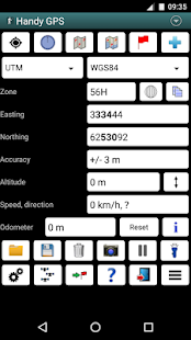
* Shows current location in easting/northing (UTM) or lat/lon
* Shows speed, direction of travel, distance travelled in either metric or imperial/US units
* Can store current location as a waypoint, and can store track logs
* Waypoints and track logs can be imported from and exported to Google Earth KML and GPX files
* Allows manual entry of waypoint coordinates in UTM, MGRS or lat/lon
* Custom waypoint symbols
* Can guide you to a waypoint with the "Goto" screen, with optional audible proximity alert
* Has magnetic compass page (devices with mag sensors only)
* Computes local magnetic declination and geoid correction at startup using the IGRF-12 and EGM96 models
* Can display either a simple map of your current location and the stored waypoints, or a Google Map
* Supports the world-wide WGS84 datum along with the Australian datums AGD66, AGD84, GDA94. (You can also use WGS84 for NAD83 maps)
* Shows satellite locations and signal strengths graphically
* Can display simple 6, 8 or 10 digit grid refs, or MGRS grid ref.
* Waypoint-to-waypoint distance and direction
* Optional timer to record walk duration and compute average speed
* Can be used instead of "MyTracks" app
* Thoroughly tested by developer on many off-track walks
EXTRA FEATURES IN THIS VERSION:
* Unlimited number of waypoints and track log points. (Free version limited to 3 waypoints and 20 tracklog points)
* Email or SMS containing a clickable link showing your location can be sent to a friend.
* Common datums such as NAD83 (US), OSGB36 (UK), NZTM2000 (NZ), SAD69 (South America) and ED50 (Europe) can be selected from the custom datum page, or you can configure your own datums, including local grid systems (such as those used at mine sites). You can also load and save datum params.
* UK grid refs with two letter prefixes can be shown if OSGB datum selected. OSGB grid refs can also be shown on smartwatches.
* Elevation profile of your route can be shown.
* Average GPS locations over time to give more accurate result.
* Take photos from the app which are optionally geotagged, or have the location "burnt" into image.
* Show sun rise and set times.
* Export waypoints to CSV file in current coordinate system.
* Create a new waypoint by projecting an existing one using an entered distance and bearing.
* Compute length, area, and elevation change for tracklog.
* Offline map support by downloading tiles from map tile servers, or using your own map images.
* Comes complete with an Android Wear version for use on your Android Wear smartwatch.
PERMISSIONS: (1) GPS - to determine your location, (2) Network access - for access to Google Map and OSM tiles, (3) SD card access - to load and store waypoints and tracklogs, (4) Camera access for taking pics, (5) Prevent phone from sleeping so that proximity alarm works, (6) Control flashlight, to allow the flashlight to be turned on/off from within the app, and (7) System settings, to allow the Android Wear app to control the watch screen brightness.
DISCLAIMER: You use this app at your own risk. The developer accepts no responsibility for you getting lost as a result of using this app. Batteries in mobile devices can go flat. An alternate power source is recommended for extended hikes.
See the Coordinate Master app for support for more coordinate systems. Handy GPS is also available for iPhone and Windows Phone.
完美的伴侣为你的下一个户外探险。寻找,发现,记录和使用Handy GPS回家。
这个程序是一个真正的导航工具专为户外运动,如远足,丛林徒步旅行,山地自行车,皮划艇和步道骑行。它也非常适合像采矿,林业,考古用途。它使用简单,即使是在最偏远的背上的国家工作,因为它并不需要网络连接。它可以让你在UTM或纬度/经度坐标的工作,这样你就可以用你的论文的地形图使用它。记录在该领域的航点和轨迹日志可以在谷歌地球以后查看。
基本特征:
*显示在东向/北向当前位置(UTM)或经/纬度
*显示速度,行驶方向,距离,无论是公制或英制/美制单位前往
*可存储当前位置为航点,并且可以存储跟踪日志
*航点和跟踪日志可以从导入和导出到谷歌地球KML和GPX文件
*允许航点的手动输入的坐标UTM,MGRS或纬度/经度
*自定义航点符号
*可以引导你到一个航点的“转到”屏幕,可选发声接近警报
*具有磁罗盘页面(设备只有MAG传感器)
*计算当地的磁偏角和大地水准面校正在启动时使用IGRF-12和EGM96模型
*可以显示您当前位置的简单地图和存储的航点,或谷歌地图
*支持与澳大利亚基准AGD66,AGD84,GDA94沿着世界各地的WGS84数据。 (您也可以使用WGS84为NAD83图)
*显示卫星的位置和信号强度图形
*可以显示简单的6,8或10位网格裁判,或MGRS网格参考。
*航点到航点的距离和方向
*可选定时器记录的步行时间和计算平均速度
*可用于代替“MyTracks”应用
*彻底开发商在许多测试偏离轨道行走
额外的功能在这个版本:
*航点和轨迹记录点的数量不受限制。 (免费版仅限于3航点和20点的追踪记录)
*电子邮件或含显示你的位置可点击的链接可以发送短信给朋友。
*如NAD83(美国),OSGB36(英国),NZTM2000(NZ),SAD69(南美洲)和ED50(欧洲)共同基准可以从自定义数据页面中选择,也可以配置自己的基准,包括本地网格系统(例如那些在矿场使用)。您还可以加载和保存数据PARAMS。
如果选择OSGB数据可以看出*用两个字母前缀的英国电网裁判。 OSGB格参也可以在智能手表中。
*路线的高度配置文件可以证明。
*随着时间的推移平均GPS位置给更准确的结果。
*拍照从中任选地理标记的应用程序,或者有位置“烧”成图像。
*显示日出和日落时间。
*出口航点到CSV文件在当前坐标系。
*创建通过投影使用输入的距离和方位现有一个新的航点。
*计算长度,面积和高度为追踪记录变化。
*从地图图块服务器下载的瓷砖,或使用自己的地图图像离线地图的支持。
*来完成一个Android Wear版本上使用您的Android Wear智能手表。
权限:(1)全球定位系统 - 来确定你的位置,(2)网络访问 - 访问谷歌地图和OSM瓷砖,(3)SD卡存取 - 来加载和存储航点和tracklogs,(4)进行拍摄图片相机接入(5)睡眠,使接近报警工程;阻止手机,(6)控制手电筒,让手电从应用程序内打开/关闭,(7)系统设置,让Android Wear应用控制手表屏幕亮度。
免责声明:您需要您自担风险使用此应用。开发人员接受你不承担任何责任迷路因为使用这个应用程序的结果。在移动设备中的电池可以走平。备用电源,建议延长上涨。
见支持协调主应用程序更多的坐标系。手持GPS也可用于iPhone和Windows Phone。
