The perfect companion for your next outdoor adventure. Seek, find, record and return home with Handy GPS.
This app is a real navigation tool designed for outdoors sports like hiking, bushwalking, mountain biking, kayaking and trail riding. It is also well suited to uses like mining, forestry, and archaeology. Its simple to use and works even in the remotest back country since it doesn't need network connectivity. It allows you to work in UTM or lat/lon coordinates so you can use it with your paper topographic maps. Waypoints and track logs recorded in the field can be be viewed later in Google Earth.
BASE FEATURES:
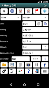
* Shows current location in easting/northing (UTM) or lat/lon
* Shows speed, direction of travel, distance travelled in either metric or imperial/US units
* Can store current location as a waypoint, and can store track logs
* Waypoints and track logs can be imported from and exported to Google Earth KML and GPX files
* Allows manual entry of waypoint coordinates in UTM, MGRS or lat/lon
* Custom waypoint symbols
* Can guide you to a waypoint with the "Goto" screen, with optional audible proximity alert
* Has magnetic compass page (devices with mag sensors only)
* Computes local magnetic declination and geoid correction at startup using the IGRF-12 and EGM96 models
* Can display either a simple map of your current location and the stored waypoints, or a Google Map
* Supports the world-wide WGS84 datum along with the Australian datums AGD66, AGD84, GDA94. (You can also use WGS84 for NAD83 maps)
* Shows satellite locations and signal strengths graphically
* Can display simple 6, 8 or 10 digit grid refs, or MGRS grid ref.
* Waypoint-to-waypoint distance and direction
* Optional timer to record walk duration and compute average speed
* Can be used instead of "MyTracks" app
* Thoroughly tested by developer on many off-track walks
EXTRA FEATURES IN THIS VERSION:
* Unlimited number of waypoints and track log points. (Free version limited to 3 waypoints and 20 tracklog points)
* Email or SMS containing a clickable link showing your location can be sent to a friend.
* Common datums such as NAD83 (US), OSGB36 (UK), NZTM2000 (NZ), SAD69 (South America) and ED50 (Europe) can be selected from the custom datum page, or you can configure your own datums, including local grid systems (such as those used at mine sites). You can also load and save datum params.
* UK grid refs with two letter prefixes can be shown if OSGB datum selected. OSGB grid refs can also be shown on smartwatches.
* Elevation profile of your route can be shown.
* Average GPS locations over time to give more accurate result.
* Take photos from the app which are optionally geotagged, or have the location "burnt" into image.
* Show sun rise and set times.
* Export waypoints to CSV file in current coordinate system.
* Create a new waypoint by projecting an existing one using an entered distance and bearing.
* Compute length, area, and elevation change for tracklog.
* Offline map support by downloading tiles from map tile servers, or using your own map images.
* Comes complete with an Android Wear version for use on your Android Wear smartwatch.
PERMISSIONS: (1) GPS - to determine your location, (2) Network access - for access to Google Map and OSM tiles, (3) SD card access - to load and store waypoints and tracklogs, (4) Camera access for taking pics, (5) Prevent phone from sleeping so that proximity alarm works, (6) Control flashlight, to allow the flashlight to be turned on/off from within the app, and (7) System settings, to allow the Android Wear app to control the watch screen brightness.
DISCLAIMER: You use this app at your own risk. The developer accepts no responsibility for you getting lost as a result of using this app. Batteries in mobile devices can go flat. An alternate power source is recommended for extended hikes.
See the Coordinate Master app for support for more coordinate systems. Handy GPS is also available for iPhone and Windows Phone.
あなたの次の屋外の冒険のための完璧なコンパニオン。シーク、見つける、レコードやハンディGPSで帰宅。
このアプリは、ハイキング、ブッシュウォーキング、マウンテンバイク、カヤック、トレイルライディングなどのアウトドアスポーツのために設計された実際のナビゲーションツールです。また、鉱業、林業、および考古学などの用途に適しています。その使用方法は簡単、それがネットワーク接続を必要としないので、でも遠いバックカントリーで動作します。それはあなたの紙の地形図とそれを使用できるように調整しますが、UTMや緯度/経度で作業することができます。フィールドに記録ウェイポイントとトラックログは、Google Earthで、後に見ることができます。
BASEの特徴:
*東距/北距(UTM)または緯度/経度に現在位置を表示します
*速度、進行方向、メトリックまたは帝国のいずれか/米国単位での走行距離を表示します
*ウェイポイントとして現在の位置を保存することができ、トラックログを保存することができます
*ウェイポイントとトラックログはからインポートし、Google EarthのKMLやGPXファイルにエクスポートすることができます
*ウェイポイントの手動入力はUTM、MGRSまたは緯度/経度の座標できます
*カスタムウェイポイントシンボル
*オプションの可聴近接警告で、「後藤」画面でウェイポイントへご案内することができます
*磁気コンパスページ(のみMAGセンサーを持つデバイス)を持っています
* IGRF-12とEGM96モデルを使用して、起動時にローカル磁気偏角とジオイド補正を計算します
*あなたの現在の場所の簡単な地図や保存されているウェイポイント、またはGoogleマップのいずれかを表示することができます
*オーストラリアのデータムAGD66、AGD84、GDA94と一緒に世界的なWGS84データムをサポートします。 (またNAD83マップのWGS84を使用することができます)
*グラフィカル衛星の位置と信号強度を表示します
*シンプルな6、8または10桁のグリッド参考文献、またはMGRSグリッドリファレンスを表示することができます。
*ウェイポイント・ツー・ウェイポイントまでの距離と方向
散歩の時間を記録し、平均速度を計算する*オプションタイマー
*代わりに「MyTracks」アプリを使用することができます
*徹底的に多くのオフトラック散歩上の現像剤によってテスト
このバージョンにおける余分な機能:
*ウェイポイントとトラックログポイント数は無制限。 (3ウェイポイントと20トラックログポイントに限定無料版)
* Eメールまたはあなたの場所を示すクリック可能なリンクを含むSMSを友人に送信することができます。
*このようなNAD83(米国)、OSGB36(英国)、NZTM2000(NZ)、SAD69(南アメリカ)およびED50(ヨーロッパ)などの一般的な基準点は、カスタム基準ページから選択することができ、またはローカルグリッドを含め、独自の基準点を設定することができます(このような鉱山現場で使用されるものなど)のシステム。また、データムのparamsをロードして保存することができます。
OSGBのデータが選択された場合、2つの文字のプレフィックスを持つ*英国グリッド参考文献を示すことができます。 OSGBグリッド参考文献もsmartwatchesに示すことができます。
*あなたのルートの標高プロファイルを示すことができます。
*経時平均GPS位置は、より正確な結果を与えます。
*必要に応じてジオタグ付きのあるアプリから写真を撮る、またはイメージに場所 "焦げ"を持っています。
*太陽の上昇を表示し、時間を設定します。
*現在の座標系内のCSVファイルにエクスポートウェイポイント。
*入力された距離とベアリングを使用して、既存のものを投影して、新しいウェイポイントを作成します。
*トラックログのための計算の長さ、面積、標高変化。
*地図タイルサーバからのタイルをダウンロードしたり、あなた自身の地図画像を使用して、オフラインマップのサポート。
*あなたのAndroid Wearのスマートウォッチで使用するためのAndroid Wearバージョンが付属しています。
権限:(1)GPS - あなたの位置を決定する、(2)ネットワークアクセス - GoogleマップとOSMのタイル、(3)SDカードへのアクセスへのアクセスのための - ウェイポイントとトラックログを読み込みおよび格納するために、写真を撮るための(4)カメラへのアクセス、(5)その結果、近接警報作品を寝てから電話を防ぐ、(6)コントロール懐中電灯、懐中電灯アプリの中からオン/オフできるようにするために、および(7)システム設定、コントロールにAndroid Wearアプリを許可します時計画面の明るさ。
免責事項:あなたがあなた自身のリスクでこのアプリを使用しています。開発者は、あなたがこのアプリを使用した結果として迷子については一切責任を負いません。モバイル機器の電池が平らに行くことができます。代替電源は延長ハイキングにお勧めです。
より多くの座標系のサポートのためのマスターCoordinateアプリを参照してください。ハンディGPSはまた、iPhoneとWindows Phoneのために利用可能です。
