The perfect companion for your next outdoor adventure. Seek, find, record and return home with Handy GPS.
IMPORTANT !! You must enable the high accuracy (GPS) location mode to use this app. To get a GPS fix, make sure you are outside, and wait. It will not work indoors
This app is a real navigation tool designed for outdoors sports like hiking, bushwalking, mountain biking, kayaking and trail riding. Its simple to use and works even in the remotest back country since it doesn't need network connectivity. It allows you to work in UTM or lat/lon coordinates so you can use it with your paper topographic maps. Waypoints and track logs recorded in the field can be be viewed later in Google Earth.
NOTE: This is a free trial version and is limited to storing only 3 waypoints, and 20 track log points. You can use the trial version for as long as you want, with no ads, but if you like this app, please install the paid version of "Handy GPS" to get an unlimited version with lots more features. Thanks!
Base features:
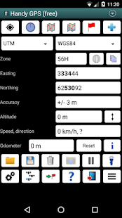
* Shows your current location in easting/northing (UTM) or lat/lon
* Shows your speed, direction of travel, and total distance travelled in either metric or imperial/US units
* Can store your current location as a waypoint, and can store a track log to show where you've been
* Waypoints and track logs can be imported from and exported to Google Earth KML and GPX files
* Allows manual entry of waypoints in UTM, MGRS or lat/lon coords
* Can guide you to a waypoint with the "Goto" screen using true or compass bearings
* Optional audible proximity alarm on goto page
* Has a magnetic compass page (on devices with mag sensors only)
* Computes the local magnetic declination at startup using the IGRF-12 model, for use on the goto page.
* Automatically computes geoid correction at startup to improve altitude accuracy
* Can display either a simple map of your current location and the stored waypoints, or a Google Map if a data connection is available
* Supports the world-wide WGS84 datum along with the Australian datums and map grids AGD66, AGD84, GDA94, AGD, GDA, AMG, and MGA. (You can also use WGS84 for NAD83 maps)
* Shows satellite locations and signal strengths graphically
* Can display simple or MGRS grid refs
* Waypoint-to-waypoint distance and direction
* Optional timer to record walk duration and compute average speed
* Has online help pages
* Now comes complete with an Android Wear version for use on your Android Wear smartwatch. (This has the same functionality as the HandyGPSWearFree app used to have. As before, the free Wear version is limited to storing only 1 waypoint)
* Can be used instead of "MyTracks" app
* Thoroughly tested by developer on many off-track walks
Extra features available only in the paid version:
* No ads.
* An unlimited number of waypoints and track log points. (The free version is limited to 3 waypoints and 20 tracklog points)
* Offline maps.
* Custom datums.
* Elevation profile.
* Take photos from the app.
* Email or SMS your location to a friend.
* UK grid refs.
* GPS averaging to improve location accuracy,
* Sun rise and set times.
* Export waypoints to CSV file.
* Project waypoints using bearing and distance.
* Compute length, area, and elevation change from tracklog.
Permissions required: (1) GPS - to determine your location, (2) Network access - for access to Google Map tiles, (3) SD card access - to load and store waypoints and tracklogs, (4) Camera access for taking pics (only available in full version), (5) Prevent phone from sleeping so that proximity alarm works, and (6) Modify system settings to allow the Wear version to dim the watch screen.
Disclaimer: You use this app at your own risk. The developer accepts no responsibility for you getting lost as a result of using this app. Batteries in mobile devices can go flat. An alternate power source is recommended for extended hikes.
Note that this app is also now available for iPhone and Windows Phone 8.
完美的伴侣为你的下一个户外探险。寻找,发现,记录和使用Handy GPS回家。
注意!!您必须启用高精度(GPS)定位方式使用此应用。为了获得GPS定位,确保你在室外,等待。它不会在室内工作
这个程序是一个真正的导航工具专为户外运动,如远足,丛林徒步旅行,山地自行车,皮划艇和步道骑行。它使用简单,即使是在最偏远的背上的国家工作,因为它并不需要网络连接。它可以让你在UTM或纬度/经度坐标的工作,这样你就可以用你的论文的地形图使用它。记录在该领域的航点和轨迹日志可以在谷歌地球以后查看。
注意:这是一个免费的试用版,仅限于只存储3航点,以及20轨迹记录点。您可以使用试用版,只要你想,没有广告,但如果你喜欢这个程序,请安装“GPS手持”的付费版本,以获得无限的版本有很多更多的功能。谢谢!
基本特点:
*显示在东向/北向(UTM)或纬度/经度您的当前位置
*显示你的速度,行进方向,并在公制或英制/美单位的总距离
*可存储您的当前位置作为航点,并可以存储轨迹记录,以显示你去过的地方
*航点和跟踪日志可以从导入和导出到谷歌地球KML和GPX文件
*允许在UTM,MGRS或纬度/经度COORDS航点的手动输入
*可以引导你到一个航点使用真实或罗盘轴承“转到”画面
*转到页可选发声接近警报
*具有磁罗盘页面(上的设备,只有MAG传感器)
*计算使用IGRF-12型在启动当地的磁偏角,对于页转到页上使用。
*启动时自动计算大地水准面校正,以提高精度的高度
*可以显示您当前位置的简单地图和存储的航点,或谷歌地图,如果数据连接
*支持与澳大利亚的基准和地图网格AGD66,AGD84,GDA94,AGD,GDA,AMG和MGA沿着世界各地的WGS84数据。 (您也可以使用WGS84为NAD83图)
*显示卫星的位置和信号强度图形
*可以显示简单的或MGRS网格裁判
*航点到航点的距离和方向
*可选定时器记录的步行时间和计算平均速度
*具有联机帮助页面
*现在来完成一个Android Wear版本上使用您的Android Wear智能手表。 (这具有相同的功能用于具有HandyGPSWearFree应用程式。和前面一样,无磨损版本被限制为仅存储1路点)
*可用于代替“MyTracks”应用
*彻底开发商在许多测试偏离轨道行走
仅在付费版额外功能:
*无广告。
*无限数量的航点和轨迹记录点。 (免费版本仅限于3航点和20点的追踪记录)
*离线地图。
*自定义基准。
*高度配置文件。
*采取从应用程序的照片。
*电子邮件或短信您的位置发送给朋友。
*英国电网裁判。
* GPS平均以提高定位精度,
*日出和日落时间。
*出口航点到CSV文件。
*使用的轴承和距离项目的航点。
*计算长度,面积和高程从追踪记录变化。
所需权限:(1)全球定位系统 - 来确定你的位置,(2)网络访问 - 访问谷歌地图图块,(3)SD卡存取 - 来加载和存储航点和tracklogs,(4)相机接入采取图片(只有在完整版中可用),(5)从休眠状态;阻止电话,以便接近警报的作品,以及(6)修改系统设置,使磨损版本变暗观看屏幕。
免责声明:您需要您自担风险使用此应用。开发人员接受你不承担任何责任迷路因为使用这个应用程序的结果。在移动设备中的电池可以走平。备用电源,建议延长上涨。
请注意,这个程序现在也可以在iPhone和Windows Phone 8。
