The perfect companion for your next outdoor adventure. Seek, find, record and return home with Handy GPS.
IMPORTANT !! You must enable the high accuracy (GPS) location mode to use this app. To get a GPS fix, make sure you are outside, and wait. It will not work indoors
This app is a real navigation tool designed for outdoors sports like hiking, bushwalking, mountain biking, kayaking and trail riding. Its simple to use and works even in the remotest back country since it doesn't need network connectivity. It allows you to work in UTM or lat/lon coordinates so you can use it with your paper topographic maps. Waypoints and track logs recorded in the field can be be viewed later in Google Earth.
NOTE: This is a free trial version and is limited to storing only 3 waypoints, and 20 track log points. You can use the trial version for as long as you want, with no ads, but if you like this app, please install the paid version of "Handy GPS" to get an unlimited version with lots more features. Thanks!
Base features:
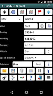
* Shows your current location in easting/northing (UTM) or lat/lon
* Shows your speed, direction of travel, and total distance travelled in either metric or imperial/US units
* Can store your current location as a waypoint, and can store a track log to show where you've been
* Waypoints and track logs can be imported from and exported to Google Earth KML and GPX files
* Allows manual entry of waypoints in UTM, MGRS or lat/lon coords
* Can guide you to a waypoint with the "Goto" screen using true or compass bearings
* Optional audible proximity alarm on goto page
* Has a magnetic compass page (on devices with mag sensors only)
* Computes the local magnetic declination at startup using the IGRF-12 model, for use on the goto page.
* Automatically computes geoid correction at startup to improve altitude accuracy
* Can display either a simple map of your current location and the stored waypoints, or a Google Map if a data connection is available
* Supports the world-wide WGS84 datum along with the Australian datums and map grids AGD66, AGD84, GDA94, AGD, GDA, AMG, and MGA. (You can also use WGS84 for NAD83 maps)
* Shows satellite locations and signal strengths graphically
* Can display simple or MGRS grid refs
* Waypoint-to-waypoint distance and direction
* Optional timer to record walk duration and compute average speed
* Has online help pages
* Now comes complete with an Android Wear version for use on your Android Wear smartwatch. (This has the same functionality as the HandyGPSWearFree app used to have. As before, the free Wear version is limited to storing only 1 waypoint)
* Can be used instead of "MyTracks" app
* Thoroughly tested by developer on many off-track walks
Extra features available only in the paid version:
* No ads.
* An unlimited number of waypoints and track log points. (The free version is limited to 3 waypoints and 20 tracklog points)
* Offline maps.
* Custom datums.
* Elevation profile.
* Take photos from the app.
* Email or SMS your location to a friend.
* UK grid refs.
* GPS averaging to improve location accuracy,
* Sun rise and set times.
* Export waypoints to CSV file.
* Project waypoints using bearing and distance.
* Compute length, area, and elevation change from tracklog.
Permissions required: (1) GPS - to determine your location, (2) Network access - for access to Google Map tiles, (3) SD card access - to load and store waypoints and tracklogs, (4) Camera access for taking pics (only available in full version), (5) Prevent phone from sleeping so that proximity alarm works, and (6) Modify system settings to allow the Wear version to dim the watch screen.
Disclaimer: You use this app at your own risk. The developer accepts no responsibility for you getting lost as a result of using this app. Batteries in mobile devices can go flat. An alternate power source is recommended for extended hikes.
Note that this app is also now available for iPhone and Windows Phone 8.
다음 야외 모험을위한 완벽한 동반자. 추구 발견, 기록 및 핸디 GPS와 함께 집으로 돌아갑니다.
중요! 당신은이 응용 프로그램을 사용하여 높은 정확도 (GPS) 위치 모드를 사용하도록 설정해야합니다. GPS를 수정 프로그램을 얻으려면, 당신은 외부, 그리고 대기해야합니다. 그것은 실내에서 작동하지 않습니다
이 응용 프로그램은 부시 워킹 하이킹, 산악 자전거, 카약, 트레일 승마 등 야외 스포츠를 위해 설계된 실제 탐색 도구입니다. 이 네트워크 연결이 필요하지 않기 때문에 간단한 사용하고도 먼 다시 나라에서 작동합니다. 그것은 당신이 당신의 종이 지형도와 함께 사용할 수 있도록 좌표는 UTM 또는 위도 / 경도에서 작업 할 수 있습니다. 필드에 기록 된 웨이 포인트 및 트랙 로그는 구글 어스에서 나중에 볼 수 있습니다.
참고 :이 무료 평가판 버전입니다 만 3 웨이 포인트, 20 트랙 로그 포인트를 저장 제한됩니다. 당신은 어떤 광고, 당신이 원하는만큼의 평가판을 사용하지만,이 응용 프로그램을 좋아한다면, 많은 더 많은 기능과 무제한 버전을 얻을 "핸디 GPS '의 유료 버전을 설치하시기 바랍니다 수 있습니다. 감사!
기본 기능 :
* Y 좌표 / X 좌표 (UTM) 또는 위도 / 경도에 현재 위치를 표시합니다
* 당신의 속도, 이동 방향을 표시하고 총 거리 중 하나 메트릭 또는 제국 / US 단위로 여행
* 웨이 포인트로 현재 위치를 저장할 수 있습니다, 당신은 어디 있었는지 보여주기 위해 트랙 로그를 저장할 수 있습니다
* 웨이 포인트 및 트랙 로그에서 가져온 Google 어스 KML과 GPX 파일로 내보낼 수 있습니다
* UTM, MGRS 또는 위도 / 경도 좌표의 중간 지점을 수동으로 입력 할 수 있습니다
* true 또는 나침반 베어링을 사용하여 "고토"화면 웨이 포인트로 안내 할 수
* 고토 페이지에서 선택 사항 청취 근접 경보
* (만 마그네틱 센서 장치) 자기 나침반 페이지가
* 고토 페이지에 사용하기 위해 IGRF-12 모델을 사용하여 시작시 로컬 자기 편각을 계산합니다.
* 자동 고도의 정확성을 개선하기 위해 시작시 지오이드 보정을 계산
데이터 연결을 사용할 수있는 경우 * 현재 위치의 간단한지도와 저장된 웨이 포인트, 또는 Google지도를 표시 할 수 있습니다
* 호주 데이텀 및지도 그리드 AGD66, AGD84, GDA94, AGD, GDA, AMG 및 MGA과 함께 전 세계적으로 WGS84 데이텀을 지원합니다. (당신은 또한 NAD83지도를 WGS84를 사용할 수 있습니다)
* 그래픽 위성 위치와 신호 강도를 표시합니다
* 단순 또는 MGRS 그리드 심판을 표시 할 수 있습니다
* 웨이 포인트 - 투 - 웨이 포인트 거리와 방향
* 옵션 기록 도보 시간에 타이머와 평균 속도를 계산
* 온라인 도움말 페이지를 가지고
* 이제 Android Wear의 스마트 워치에 사용하기위한 Android Wear 버전과 완벽하게 제공. (이 가지고 사용 HandyGPSWearFree 응용 프로그램과 같은 기능을 갖는다. 이전과 같이, 자유웨어 버전은 1 웨이 기억에 한정된다)
* 대신 "운동 기록"응용 프로그램의 사용 가능
트랙 오프 산책 * 철저 많은에 개발자가 테스트
만 유료 버전에서 사용할 수있는 추가 기능 :
* 광고 없음.
* 웨이 포인트 및 트랙 로그 포인트의 무제한. (무료 버전은 3 웨이 포인트 20 tracklog 포인트로 제한됩니다)
* 오프라인지도.
* 사용자 정의 데이텀.
* 고도 프로필.
* 응용 프로그램에서 사진을 가져 가라.
* 이메일 또는 친구에게 위치를 SMS.
* 영국 그리드 심판.
* 위치 정확도를 향상시키기 위해 평균화 GPS,
* 태양 상승과 세트 시간.
* CSV 파일로 내보내기 웨이 포인트.
* 베어링과 거리를 사용하여 프로젝트의 중간 점.
* tracklog에서 계산 길이, 면적 및 높이 변화.
사용 권한이 필요합니다 : (1) GPS - (사진을 주셔서로드 및 저장 웨이 포인트와 tracklogs, (4) 카메라 사용 - Google지도 타일에 대한 접근, (3) SD 카드 액세스 - 사용자의 위치, (2) 네트워크 액세스를 결정하기 위해 ) 가득 차있는 버전에서만 사용할 수, (5) 그래서 근접 경보가 작동 수면에서 전화를 방지하고, (6)웨어 버전이 시계 화면을 어둡게 할 수 있도록 시스템 설정을 수정합니다.
면책 조항 : 당신은 당신의 자신의 위험이 응용 프로그램을 사용합니다. 개발자는 당신에 대한 책임이 응용 프로그램을 사용의 결과로 손실되지지고 받아들입니다. 모바일 기기의 배터리는 평면 갈 수 있습니다. 대체 전원 연장 인상하는 것이 좋습니다.
이 응용 프로그램은 또한 아이폰과 윈도우 폰 8에 사용할 수 있습니다합니다.
