
Geotag Photos Pro is professional geotagging solution - all you need to geotag photos taken by your EXTERNAL camera (DSLR, mirrorless or compact one). It supports JPG & RAW photos and its data can be used also with Lightroom, Aperture, Picasa and other photo apps that supports geotagged photos.
Try 3 trips for FREE and then unlock the full app for a one time fee.
Geotag Photos Pro is praised by industry experts
- Geotagging App of the Year by Macworld
- Repeatedly recommended by leading Adobe Lightroom professionals
- Recommended in many great books such as Lightroom 4 UnMasked, Lightroom 4 the missing FAQ, Lightroom 4 Roadmap for photographers
- Praised by leading photography magazines and websites all over the world (Techradar, Ephotozine, Fotomaf, Xatakafoto, Lightroom Secrets, Digital-Fotografie, Pixelmania.nl, Photoplus...)
Best facts about Geotag Photos Pro
- Complete solution - mobile app records your position while you’re taking great photos and a desktop app geotags your images using recorded data.
- Flawless Lightroom Compatibility - GPX files from the app work flawlessly inside Lightroom’s Map module for geotagging
- Dropbox and Google Drive support - automatically export all your trips as GPX files
- Smart watch app - dedicated app for Android Wear and Pebble to control app from your wrist ! Automatic trip upload - the app automatically sync all your trips ( you can switch to manual uploads in settings)
- Battery usage optimized for whole day of geotagging
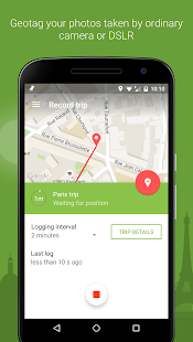
- Choose the logging interval and accuracy for whatever you need
- Organized trips history
- Statistics of your trips
- Export to GPX
FREE desktop geotagging app
Adds GPS location to your your JPG or RAW photos quickly and easily! Works both online and offline and there are version for any operating system - Mac OS X, Windows and even Linux
Supported image formats: jpg, nef, cr2, crw, dcr, ciff, erf, orf, k25, kdc, mef, mrw, nrw, pef, raf, tif, tiff, raw, arw, rw2, srf, sr2, srw, x3f, dng
Visit our website for more info http://www.geotagphotos.net
Geotag Foto Pro è la soluzione di geotagging professionale - tutto quello che dovete geotag foto scattate dalla fotocamera ESTERNO (DSLR, mirrorless o una compatta). Supporta JPG e RAW foto ei suoi dati possono essere utilizzati anche con Lightroom, Aperture, Picasa e altre applicazioni fotografiche che supporta foto georeferenziate.
Prova 3 viaggi GRATIS e quindi sbloccare l'applicazione completa per una tassa di una volta.
Geotag Foto Pro è lodato dagli esperti del settore
- Geotagging App of the Year da Macworld
- Ripetutamente raccomandato da importanti professionisti Adobe Lightroom
- Consigliato in molti grandi libri come Lightroom 4 Unmasked, Lightroom 4 le FAQ mancante, Lightroom 4 tabella di marcia per i fotografi
- Sia lodato da importanti riviste di fotografia e siti web di tutto il mondo (TechRadar, ePHOTOzine, Fotomaf, Xatakafoto, segreti Lightroom, Digital-Fotografie, Pixelmania.nl, PhotoPlus ...)
Migliori fatti circa Geotag Foto Pro
- Soluzione completa - mobile app registra la tua posizione mentre si sta prendendo grandi foto e un'applicazione desktop geotag le immagini utilizzando i dati registrati.
- Flawless Lightroom Compatibilità - i file GPX del lavoro applicazione senza problemi all'interno di modulo Map Lightroom per il geotagging
- Dropbox e supporto Google Drive - esportare automaticamente tutti i vostri viaggi come file GPX
- Applicazione intelligente orologio - app dedicata per controllare app dal polso Android e usura Pebble! Upload automatico viaggio - l'applicazione sincronizza automaticamente tutti i vostri viaggi (si può passare ai caricamenti manuali nelle impostazioni)
- L'utilizzo delle batterie ottimizzato per tutta la giornata di geotagging
- Scegliere l'intervallo di registrazione e precisione per qualsiasi cosa avete bisogno
- Storia Viaggi organizzati
- Le statistiche dei vostri viaggi
- Esportazione in formato GPX
un'applicazione desktop LIBERO geotagging
Aggiunge posizione GPS al vostro JPG o foto in formato RAW rapidamente e facilmente! Funziona sia in versione online e offline e ci sono per qualsiasi sistema operativo - Mac OS X, Windows e anche Linux
Formati di immagine supportati: jpg, nef, cr2, CRW, DCR, ciff, ERF, ORF, K25, KDC, mef, MRW, nrw, PEF, RAF, tif, tiff, crudo, ARW, RW2, SRF, SR2, SRW, X3F, DNG
Visita il nostro sito per maggiori informazioni http://www.geotagphotos.net
