The perfect companion for your next outdoor adventure. Seek, find, record and return home with Handy GPS.
This app is a real navigation tool designed for outdoors sports like hiking, bushwalking, mountain biking, kayaking and trail riding. It is also well suited to uses like mining, forestry, and archaeology. Its simple to use and works even in the remotest back country since it doesn't need network connectivity. It allows you to work in UTM or lat/lon coordinates so you can use it with your paper topographic maps. Waypoints and track logs recorded in the field can be be viewed later in Google Earth.
BASE FEATURES:
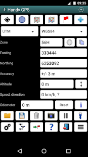
* Shows current location in easting/northing (UTM) or lat/lon
* Shows speed, direction of travel, distance travelled in either metric or imperial/US units
* Can store current location as a waypoint, and can store track logs
* Waypoints and track logs can be imported from and exported to Google Earth KML and GPX files
* Allows manual entry of waypoint coordinates in UTM, MGRS or lat/lon
* Custom waypoint symbols
* Can guide you to a waypoint with the "Goto" screen, with optional audible proximity alert
* Has magnetic compass page (devices with mag sensors only)
* Computes local magnetic declination and geoid correction at startup using the IGRF-12 and EGM96 models
* Can display either a simple map of your current location and the stored waypoints, or a Google Map
* Supports the world-wide WGS84 datum along with the Australian datums AGD66, AGD84, GDA94. (You can also use WGS84 for NAD83 maps)
* Shows satellite locations and signal strengths graphically
* Can display simple 6, 8 or 10 digit grid refs, or MGRS grid ref.
* Waypoint-to-waypoint distance and direction
* Optional timer to record walk duration and compute average speed
* Can be used instead of "MyTracks" app
* Thoroughly tested by developer on many off-track walks
EXTRA FEATURES IN THIS VERSION:
* Unlimited number of waypoints and track log points. (Free version limited to 3 waypoints and 20 tracklog points)
* Email or SMS containing a clickable link showing your location can be sent to a friend.
* Common datums such as NAD83 (US), OSGB36 (UK), NZTM2000 (NZ), SAD69 (South America) and ED50 (Europe) can be selected from the custom datum page, or you can configure your own datums, including local grid systems (such as those used at mine sites). You can also load and save datum params.
* UK grid refs with two letter prefixes can be shown if OSGB datum selected. OSGB grid refs can also be shown on smartwatches.
* Elevation profile of your route can be shown.
* Average GPS locations over time to give more accurate result.
* Take photos from the app which are optionally geotagged, or have the location "burnt" into image.
* Show sun rise and set times.
* Export waypoints to CSV file in current coordinate system.
* Create a new waypoint by projecting an existing one using an entered distance and bearing.
* Compute length, area, and elevation change for tracklog.
* Offline map support by downloading tiles from map tile servers, or using your own map images.
* Comes complete with an Android Wear version for use on your Android Wear smartwatch.
PERMISSIONS: (1) GPS - to determine your location, (2) Network access - for access to Google Map and OSM tiles, (3) SD card access - to load and store waypoints and tracklogs, (4) Camera access for taking pics, (5) Prevent phone from sleeping so that proximity alarm works, (6) Control flashlight, to allow the flashlight to be turned on/off from within the app, and (7) System settings, to allow the Android Wear app to control the watch screen brightness.
DISCLAIMER: You use this app at your own risk. The developer accepts no responsibility for you getting lost as a result of using this app. Batteries in mobile devices can go flat. An alternate power source is recommended for extended hikes.
See the Coordinate Master app for support for more coordinate systems. Handy GPS is also available for iPhone and Windows Phone.
다음 야외 모험을위한 완벽한 동반자. 추구 발견, 기록 및 핸디 GPS와 함께 집으로 돌아갑니다.
이 응용 프로그램은 부시 워킹 하이킹, 산악 자전거, 카약, 트레일 승마 등 야외 스포츠를 위해 설계된 실제 탐색 도구입니다. 또한 잘 광업, 임업, 고고학 등의 용도에 적합합니다. 이 네트워크 연결이 필요하지 않기 때문에 간단한 사용하고도 먼 다시 나라에서 작동합니다. 그것은 당신이 당신의 종이 지형도와 함께 사용할 수 있도록 좌표는 UTM 또는 위도 / 경도에서 작업 할 수 있습니다. 필드에 기록 된 웨이 포인트 및 트랙 로그는 구글 어스에서 나중에 볼 수 있습니다.
BASE 특징 :
* 현재의 Y 좌표의 /의 X 좌표의 위치 (UTM) 또는 위도 / 경도를 표시합니다
* 거리 중 하나 메트릭 또는 제국 / US 단위로 여행, 속도, 이동 방향을 표시
*는 웨이 포인트로 현재 위치를 저장할 수 있으며, 트랙 로그를 저장할 수 있습니다
* 웨이 포인트 및 트랙 로그에서 가져온 Google 어스 KML과 GPX 파일로 내보낼 수 있습니다
* 웨이 포인트의 수동 입력이 UTM 좌표 MGRS 또는 위도 / 경도를 할 수 있습니다
* 사용자 정의 웨이 포인트 심볼
* 옵션 가청 근접 경보과 함께 "고토"화면 웨이 포인트로 안내 할 수
* (만 마그네틱 센서 장치) 자기 나침반 페이지가
* IGRF-12 및 EGM96 모델을 사용하여 시작시 지역의 자기 편각과 지오이드 보정을 계산
* 현재 위치의 간단한지도와 저장된 웨이 포인트, 또는 Google지도를 표시 할 수 있습니다
* 호주 데이텀 AGD66, AGD84, GDA94와 함께 세계적으로 WGS84 데이텀을 지원합니다. (당신은 또한 NAD83지도를 WGS84를 사용할 수 있습니다)
* 그래픽 위성 위치와 신호 강도를 표시합니다
* 간단한 6, 8 또는 10 자리 그리드 심판, 또는 MGRS 그리드 심판을 표시 할 수 있습니다.
* 웨이 포인트 - 투 - 웨이 포인트 거리와 방향
* 옵션 기록 도보 시간에 타이머와 평균 속도를 계산
* 대신 "운동 기록"응용 프로그램의 사용 가능
트랙 오프 산책 * 철저 많은에 개발자가 테스트
이 버전의 추가 기능 :
* 웨이 포인트 및 트랙 로그 포인트 무제한. (무료 버전은 3 웨이 포인트 20 tracklog 포인트에 한함)
* 이메일 또는 사용자의 위치를 나타내는 클릭 가능한 링크가 포함 된 SMS는 친구에게 보낼 수 있습니다.
* 같은 NAD83 (미국), OSGB36 (UK), NZTM2000 (NZ), SAD69 (남미) 및 ED50 (유럽) 등의 공통 데이텀은 사용자 정의 데이텀 페이지에서 선택하거나 로컬 그리드를 포함하여, 자신의 데이텀을 구성 할 수 있습니다 (예 : 광산 현장에서 사용되는 것과 같은) 시스템. 또한로드 데이텀 PARAMS을 절약 할 수 있습니다.
OSGB 데이텀를 선택한 경우 두 글자 접두사와 * 영국 그리드 심판은 표시 할 수 있습니다. OSGB 그리드 심판은 smartwatches에 표시 할 수 있습니다.
* 경로의 고도 프로파일을 표시 할 수 있습니다.
* 시간 경과 평균 GPS 위치가 더 정확한 결과를 얻었다.
* 선택적으로 위치 정보 태그 된 앱에서 사진을 찍어, 또는 이미지에 위치 "탄"이 있습니다.
*보기 태양 상승 및 시간을 설정합니다.
* 좌표 현재 시스템에서 CSV 파일로 내보내기 웨이 포인트.
* 입력 된 거리와 베어링을 사용하여 기존의 돌출하여 새 웨이 포인트를 작성합니다.
* tracklog에 대한 계산 길이, 면적 및 높이 변화.
*지도 타일 서버에서 타일을 다운로드하거나 자신의지도 이미지를 사용하여 오프라인지도를 지원합니다.
* 당신의 Android Wear 스마트 워치에 사용하기위한 Android Wear 버전에 완전한 온다.
승인 : (1) GPS - (3) SD 카드 액세스, 구글지도 OSM 타일에 액세스 - - (2) 네트워크 액세스, 사용자의 위치를 결정하기 위해 사진을 촬영로드 및 저장 웨이 포인트와 tracklogs, (4) 카메라 액세스 (5) 손전등은 앱 내에서 설정 / 해제 할 수 있도록, (6) 제어 손전등, 그래서 근접 경보 작동 수면에서 전화를 방지하고, (7) 시스템 설정, 제어 Android Wear 앱을 허용 시계 화면 밝기.
면책 조항 : 당신은 당신의 자신의 위험이 응용 프로그램을 사용합니다. 개발자는 당신에 대한 책임이 응용 프로그램을 사용의 결과로 손실되지지고 받아들입니다. 모바일 기기의 배터리는 평면 갈 수 있습니다. 대체 전원 연장 인상하는 것이 좋습니다.
좌표계를 더 지원을위한 좌표 마스터 응용 프로그램을 참조하십시오. 핸디 GPS는 아이폰과 윈도우 폰에서 사용할 수 있습니다.
