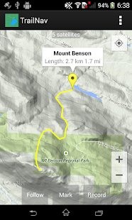
Find your way in the back country with this navigational tool. View maps, place markers, plan routes, view elevation and speed profiles, search for routes and markers, and record your movements across the land.
- Enable satellite tracking in Settings before starting
- To place a marker, tap on the map
- To plan a route, long press on the map, then tap along your route, then tap on the Record button
- While route planning, long press on the map to delete the last point
- To keep the map centred at your position, tap on the Follow button
- To keep your route pointing up, tap on the Follow button again
- To mark your current position, tap on the Follow button, wait for a satellite fix, then tap on the Mark button
- To record your movements, tap on the Follow button, then tap on the Record button
- To view a marker's information window, tap on the marker
- To rename or delete a marker, tap on the information window
- To find the flattest route, long press on the start point, then long press on the end point
- Android Wear notifications will be generated when satellite tracking or recording
- Marker detail screen will show geo tagged photos taken within 100 meters of the marker
- Graphs created using the Snowdon graphing library
- Automatic routing created using the A* search algorithm
