
Rocklogger is a geological tool for measuring the orientation of rock outcrops. It uses the phone's compass and orientation sensors to measure dip & dip direction, or dip & strike, in a single click.
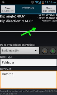
GPS and magnetic field information can also be saved, along with details on the rock plane & type.
Key features:
-Log dip & strike or dip & dip direction by placing the phone on the rock/plane in any orientation (using the rotating symbol and quick help features as guides).
-Android Wear companion app to view and save (paid only) live sensor readings from your phone remotely on your watch, and vice-versa. Alternatively, log remotely using a wired headset (paid only) as a remote control. Great for logging hard-to-reach surfaces
-Plot logs on a map, with correct dip/strike symbols
-Plot logs on alternate basemaps from various sources including MapBox, zip files and the web (paid only)
-Plot poles or planes from logs on a stereonet, and interpret by touching the plot to find trends and intersections (paid only)
-Define your own extra text and dropdown fields, to fit your logging scheme (paid only)
-Log the ambient magnetic field
-Launch the camera to take photos while logging. Notes and GPS data are saved to the log file. Photos are stored with the log file, and are automatically attached when you send a log via email from the browser screen
The log is saved to a .csv file, which can be sent to Excel / Mapinfo / etc for interpreting. Paid versions can also export KML files for use in Google Earth (Android or desktop version).
Taking the strike and dip of outcrops with a compass / declinometer usually takes a few minutes per rock. With Rocklogger, many measurements of an outcrop can be taken in seconds (in any orientation). It also works upside-down, eg for logging overhang in a mine.
The evaluation version is limited to saving 3 records per 3 minutes, and has the stereonet plotter, KML export and custom basemap features disabled. Rocklogger Unlocker is available for purchase to disable the evaluation version restrictions.
Rocklogger是用于测量岩层的取向的地质工具。它使用手机的指南针和方向感应器来测量倾角和倾向,或浸和罢工,在一个单一的点击。
GPS和磁场信息也可以保存,对岩石面和类型的详细信息。
主要特征:
-log浸染在任意方向放置在岩石/平面手机(使用旋转符号,并快速帮助功能为导向)罢工或浸染倾向。
-Android戴上配套应用查看和保存你的手表(只支付),从您的手机进行远程实时传感器读数,反之亦然。另外,远程登录使用有线耳机(仅支付)作为一个遥控器。伟大的记录难以到达的表面
在地图上 - 图日志,用正确的DIP /行使符号
从各种来源备用底图 - 图日志,包括MapBox,zip文件和Web(只付)
- 图从一个stereonet日志杆或飞机,并通过触摸情节发现趋势和十字路口解释(只付)
-define自己多余的文字和下拉领域,以适应你的日志方案(只付)
-log周围磁场
- 启动相机拍摄的照片记录时。注释和GPS数据保存到日志文件。照片存储在日志文件中,当你在浏览器屏幕通过电子邮件发送日志被自动连接
该日志保存为.csv文件,可以发送到Excel /的Mapinfo /等解释。付费版本也可以导出KML文件在谷歌地球(Android或桌面版)的使用。
以露头的走向和倾向用圆规/磁偏通常需要每摇滚几分钟。随着Rocklogger,一露头的多次测量可在数秒内拍摄(在任何方向)。它也可以颠倒,例如,用于在矿井登录悬。
评估版限制为每3分钟节省3条记录,并具有stereonet绘图仪,KML出口和自定义功能底图禁用。 Rocklogger解锁可以转让禁用评估版的限制。
