
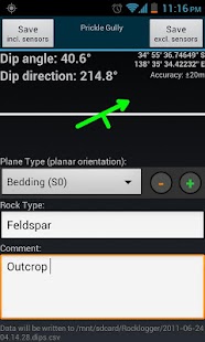
Rocklogger is a geological tool for measuring the orientation of rock outcrops. It uses the phone's compass and orientation sensors to measure dip & dip direction, or dip & strike, in a single click.
GPS and magnetic field information can also be saved, along with details on the rock plane & type.
Key features:
-Log dip & strike or dip & dip direction by placing the phone on the rock/plane in any orientation (using the rotating symbol and quick help features as guides).
-Android Wear companion app to view and save (paid only) live sensor readings from your phone remotely on your watch, and vice-versa. Alternatively, log remotely using a wired headset (paid only) as a remote control. Great for logging hard-to-reach surfaces
-Plot logs on a map, with correct dip/strike symbols
-Plot logs on alternate basemaps from various sources including MapBox, zip files and the web (paid only)
-Plot poles or planes from logs on a stereonet, and interpret by touching the plot to find trends and intersections (paid only)
-Define your own extra text and dropdown fields, to fit your logging scheme (paid only)
-Log the ambient magnetic field
-Launch the camera to take photos while logging. Notes and GPS data are saved to the log file. Photos are stored with the log file, and are automatically attached when you send a log via email from the browser screen
The log is saved to a .csv file, which can be sent to Excel / Mapinfo / etc for interpreting. Paid versions can also export KML files for use in Google Earth (Android or desktop version).
Taking the strike and dip of outcrops with a compass / declinometer usually takes a few minutes per rock. With Rocklogger, many measurements of an outcrop can be taken in seconds (in any orientation). It also works upside-down, eg for logging overhang in a mine.
The evaluation version is limited to saving 3 records per 3 minutes, and has the stereonet plotter, KML export and custom basemap features disabled. Rocklogger Unlocker is available for purchase to disable the evaluation version restrictions.
Rockloggerは岩の露頭の向きを測定するための地質学的なツールです。これは、単一のクリックで、ディップ&ディップ方向、またはディップ&ストライキを測定するために携帯電話のコンパスと方向センサーを使用しています。
GPSと磁場情報は、岩面&タイプの詳細と一緒に、保存することができます。
主な機能:
(ガイドとして回転シンボルとクイックヘルプ機能を使用して)任意の方向でロック/平面上に携帯電話を置くことによって-logディップ&ストライキやディップ&ディップ方向。
リモートであなたの時計にお使いの携帯電話から閲覧し、保存するためのコンパニオンアプリ(のみ有料の)ライブセンサーの読み取り値を着用し、その逆も-Android。また、リモートコントロールとして(のみ支払わ)有線ヘッドセットを使用してリモートログインします。手の届きにくい表面をログに記録するためのグレート
正しいディップ/ストライキのシンボルで地図上の-PLOTログ、
MapBox、zipファイルと(のみ有料の)ウェブを含む、さまざまなソースからの代替ベースマップ上-PLOTログ
-PLOT極または平面stereonet上のログから、そしてトレンドや交差点を見つけるためにプロットに触れることによって解釈(のみ支払わ)
(のみ有料の)あなたのロギング方式に合わせて、あなた自身の余分なテキストとドロップダウンフィールドを-define
周囲の磁界を-Log
ログイン中に写真を撮るためにカメラを-launch。 NotesとGPSデータがログファイルに保存されます。写真は、ログファイルに保存され、あなたがブラウザ画面から電子メールでログを送信するときに自動的に添付されています
ログは、解釈のために、Excel / MapInfoのの/ etcに送信することができます.csvファイルに保存されます。有料バージョンもグーグルアース(アンドロイドまたはデスクトップ版)で使用するためのKMLファイルをエクスポートすることができます。
コンパス/偏角計で露頭の走向と傾斜をとることは通常岩ごとに数分かかります。 Rockloggerでは、露頭の多くの測定値は、(任意の方向に)秒で撮影することができます。また、鉱山でオーバーハングを記録するために、たとえば上下逆さまに、動作します。
評価版は、3分ごとに3のレコードを保存するに限定されず、無効になってstereonetプロッタ、KMLのエクスポートおよびカスタムベースマップの機能を有しています。 Rockloggerアンロックは、評価版の制限を無効にするには購入可能です。
