The Memory-Map app turns your phone or tablet into a full-featured Outdoor GPS or Marine Chart Plotter, and allows you to navigate with Ordnance Survey Topo maps, 4WD maps or Marine charts, even without a wireless internet signal.
Maps are downloaded on-the-fly and can be pre-loaded so that they can be used offline. Once the app and maps are loaded to the phone or tablet, cellular network coverage or internet connection is not required for real time GPS navigation.
The Memory-Map app can be used as a standalone GPS navigator, but it can also be used in conjunction with the Windows PC app (free download) for planning, printing and loading up maps, waypoints and routes to the phone/tablet.
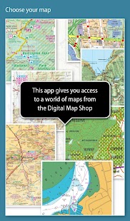
Memory-Map includes free access to 1:250,000 scale topographic maps and many other free maps around the world. More detailed maps are available for download and purchase with a free try-before-you-buy, time-limited demo option. Available maps include Ordnance Survey, Hema, USGS quads, NOAA, British Admiralty, and DeLorme. Maps can be used on your PC as well as your phone and tablet. The Cloud Sync feature allows you to keep the overlay data consistent on all your devices.
Features include:
Access a vast range of Worldwide maps and charts.
Automatically downloads a free map of your current location
Create and edit marks and routes.
Import and export marks, routes and tracks in the open GPX format
Display; Position, Course, Speed, Heading, Altitude and averages
Position coordinates include Lat/Long, UTM and GB Grid
Units displayed in Statute, Nautical or Metric
Support for GPS and Compass sensors, where available.
Placename index, can be used offline.
Moving map, lock GPS position and automatically scroll the map
Records breadcrumb trail / tracklogs.
Share position marks or tracklogs as GPX files
Proximity Alarm
Full marine instrumentation features, with AIS, DSC and Anchor alarm
NMEA data interface via WiFi or Bluetooth
AIS collision alarm, with adjustable thresholds for Class A and Class B targets
Display Alarm notifications and Nav data on Android Wear watch
"Verdict: The Memory-Map App is a truly excellent, competent product, representing real value for money. It's straightforward to use, with just enough preference settings and options to describe it as customizable. Route-creation and route-following are ridiculously easy to set up, yet provide a tremendous range of route data. You can also import and export GPX files (via email). A really strong product at this price point." Andrew Knight, Yacht Arabella blog
"After buying about 6 navigational applications for my tablet I finally got one that really works the way it should. I now have a handheld version of my sailboat's navigation system. I am very happy with this app and would recommend it to any avid sailor"
"I've tried all the mapping/tracking applications I can find and I rate this best. The 1:25k scale is essential for walkers and the ability to create a route at home or to log it (recording your time & distance etc) as you go along is superb. I like the direction indicator to show where you are heading on the map, the ability to save, describe and name tracks is neat. It's easy to slide the map about from your current position to see where you are heading next, the zooming in and out facility is good. I found it reasonably easy to learn how to use."
"This is not a cheap navigation program, it is a professional tool for viewing raster maps. And for this purpose, it is excellent. For viewing topo maps, this is the best software and hardware combination for the job, this alone was my reason to get an Android tablet, and it was the right decision."
메모리 -지도 앱은 심지어 무선 인터넷 신호없이 야외 GPS 기능을 갖춘 또는 해양 차트 플로터로 휴대 전화 나 태블릿을 회전, 당신은 병기 조사 토포지도, 4WD지도 또는 해양 차트를 탐색 할 수 있습니다.
지도는 즉석에서 다운로드하고 오프라인으로 이용 될 수 있도록 사전에로드 될 수있다. 응용 프로그램 및지도는 휴대 전화 나 태블릿에로드되면, 셀룰러 네트워크 범위 또는 인터넷 연결이 실시간 GPS 네비게이션 필요하지 않습니다.
상기 메모리 - 맵 앱 독립형 GPS 탐색기로 사용할 수 있지만, 또한, 휴대 전화 / 태블릿 계획 인쇄 로딩까지지도 경유지 및 경로에 대한 Windows PC 앱 (무료 다운로드)와 함께 사용될 수있다.
전세계 25 만 규모 지형지도 및 다른 많은 무료지도 : 메모리-지도 1을 무료로 이용할을 포함한다. 더 자세한지도는 무료 시도 - 전에 - 당신 - 구매, 시간 제한 데모 옵션을 다운로드 및 구매할 수 있습니다. 사용 가능한 맵 병기 조사, 헤마, USGS 쿼드, NOAA, 영국 해군 및 DELORME을 포함한다. 지도는 PC뿐만 아니라 휴대 전화와 태블릿에서 사용할 수 있습니다. 클라우드 동기화 기능을 사용하면 모든 기기에서 일관성있는 오버레이 데이터를 보존 할 수 있습니다.
특징은 다음과 같습니다 :
세계지도와 차트의 광대 한 범위에 액세스 할 수 있습니다.
자동으로 현재 위치의 무료지도를 다운로드
생성 및 표시 및 경로를 편집 할 수 있습니다.
가져 오기 및 내보내기 마크, 오픈 GPX 형식으로 노선 및 트랙
디스플레이; 위치, 코스, 속도, 제목, 고도 평균
위치 좌표는 위도 / 경도, UTM 및 GB 그리드를 포함
규정, 해상 또는 미터법 표시 단위
GPS와 나침반 센서, 사용할 수에 대한 지원.
· 지명 인덱스 오프라인 사용될 수있다.
이동지도, 잠금 GPS 위치와 자동으로지도를 이동
기록의 이동 경로는 / tracklogs.
GPX 파일로 공유 위치 표시 또는 tracklogs
근접 경보
AIS, DSC 및 앵커 알람 전체 해양 계측 기능,
WiFi 또는 블루투스를 통해 NMEA 데이터 인터페이스
조정 클래스 A에 대한 임계 값 및 클래스 B의 목표와 AIS 충돌 경보,
안드로이드 착용 시계에 표시 경보 알림 및 탐색 데이터
"평결 : 메모리-지도 앱은 돈을 위해 진정한 가치를 나타내는 진정으로 뛰어난 능력 제품이며, 그것은 경로-다음은 엄청나게 쉽게 같은 사용자 정의 경로 창작과를 설명하는 데 충분한 환경 설정과 옵션을 사용하는 것이 간단합니다.. 설정, 아직 경로 데이터의 엄청난 범위를 제공합니다. 당신은 또한 가져 오기 및 내보내기 GPX 파일 (이메일을 통해) 할 수 있습니다. 정말 강한 제품을이 가격으로. " 앤드류 기사, 요트 아라벨라 블로그
"내 태블릿에 대해 6 탐색 응용 프로그램을 구입 후, 나는 마침내 정말. 내가 지금 내 요트의 네비게이션 시스템의 휴대용 버전이 있어야 방식으로 작동 하나있어. 나는이 응용 프로그램과 함께 매우 기쁘게 생각하고 탐욕스러운 선원에게 추천 할 것입니다"
"내가 찾을 수있는 모든 매핑 / 추적 응용 프로그램을 시도하고 나는이 가장 좋은 평가 1 :. 25000 규모는 워커와 경로 집에서하거나 기록 할을 만들 수있는 능력에 필수적이다 (등 시간 및 거리를 기록) 당신이 따라 간다. 난 당신이지도를 향하고있다 위치를 표시하는 방향 표시기를 최상의 좋아하는 한, 능력, 저장 설명하고 이름은 깔끔한 추적합니다. 그것은 당신이 어디를 확인하려면 현재 위치에서 대한지도를 밀어 쉽게 다음 제목 밖으로 확대와 시설이 좋다. 내가 사용하는 방법에 대한 자세한 내용은 합리적으로 쉽게 발견했다. "
"이는 그것이 래스터지도를 볼 전문 공구 저렴한 네비게이션 프로그램되지 않는다. 이러한 목적을 위해,이 우수하다. TOPO지도를 볼 수 있도록,이 작업에 가장 적합한 소프트웨어와 하드웨어의 조합이며, 이는 단독으로 내 이유였다 안드로이드 태블릿을 얻을, 그것은 옳은 결정 하였다. "
