The perfect companion for your next outdoor adventure. Seek, find, record and return home with Handy GPS.
IMPORTANT !! You must enable the high accuracy (GPS) location mode to use this app. To get a GPS fix, make sure you are outside, and wait. It will not work indoors
This app is a real navigation tool designed for outdoors sports like hiking, bushwalking, mountain biking, kayaking and trail riding. Its simple to use and works even in the remotest back country since it doesn't need network connectivity. It allows you to work in UTM or lat/lon coordinates so you can use it with your paper topographic maps. Waypoints and track logs recorded in the field can be be viewed later in Google Earth.
NOTE: This is a free trial version and is limited to storing only 3 waypoints, and 20 track log points. You can use the trial version for as long as you want, with no ads, but if you like this app, please install the paid version of "Handy GPS" to get an unlimited version with lots more features. Thanks!
Base features:
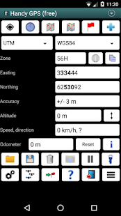
* Shows your current location in easting/northing (UTM) or lat/lon
* Shows your speed, direction of travel, and total distance travelled in either metric or imperial/US units
* Can store your current location as a waypoint, and can store a track log to show where you've been
* Waypoints and track logs can be imported from and exported to Google Earth KML and GPX files
* Allows manual entry of waypoints in UTM, MGRS or lat/lon coords
* Can guide you to a waypoint with the "Goto" screen using true or compass bearings
* Optional audible proximity alarm on goto page
* Has a magnetic compass page (on devices with mag sensors only)
* Computes the local magnetic declination at startup using the IGRF-12 model, for use on the goto page.
* Automatically computes geoid correction at startup to improve altitude accuracy
* Can display either a simple map of your current location and the stored waypoints, or a Google Map if a data connection is available
* Supports the world-wide WGS84 datum along with the Australian datums and map grids AGD66, AGD84, GDA94, AGD, GDA, AMG, and MGA. (You can also use WGS84 for NAD83 maps)
* Shows satellite locations and signal strengths graphically
* Can display simple or MGRS grid refs
* Waypoint-to-waypoint distance and direction
* Optional timer to record walk duration and compute average speed
* Has online help pages
* Now comes complete with an Android Wear version for use on your Android Wear smartwatch. (This has the same functionality as the HandyGPSWearFree app used to have. As before, the free Wear version is limited to storing only 1 waypoint)
* Can be used instead of "MyTracks" app
* Thoroughly tested by developer on many off-track walks
Extra features available only in the paid version:
* No ads.
* An unlimited number of waypoints and track log points. (The free version is limited to 3 waypoints and 20 tracklog points)
* Offline maps.
* Custom datums.
* Elevation profile.
* Take photos from the app.
* Email or SMS your location to a friend.
* UK grid refs.
* GPS averaging to improve location accuracy,
* Sun rise and set times.
* Export waypoints to CSV file.
* Project waypoints using bearing and distance.
* Compute length, area, and elevation change from tracklog.
Permissions required: (1) GPS - to determine your location, (2) Network access - for access to Google Map tiles, (3) SD card access - to load and store waypoints and tracklogs, (4) Camera access for taking pics (only available in full version), (5) Prevent phone from sleeping so that proximity alarm works, and (6) Modify system settings to allow the Wear version to dim the watch screen.
Disclaimer: You use this app at your own risk. The developer accepts no responsibility for you getting lost as a result of using this app. Batteries in mobile devices can go flat. An alternate power source is recommended for extended hikes.
Note that this app is also now available for iPhone and Windows Phone 8.
あなたの次の屋外の冒険のための完璧なコンパニオン。シーク、見つける、レコードやハンディGPSで帰宅。
重要!!あなたは、このアプリを使用するには、高精度(GPS)の位置モードを有効にする必要があります。 GPS修正を取得するには、あなたが外であり、そして待っていることを確認します。それは屋内で動作しません。
このアプリは、ハイキング、ブッシュウォーキング、マウンテンバイク、カヤック、トレイルライディングなどのアウトドアスポーツのために設計された実際のナビゲーションツールです。その使用方法は簡単、それがネットワーク接続を必要としないので、でも遠いバックカントリーで動作します。それはあなたの紙の地形図とそれを使用できるように調整しますが、UTMや緯度/経度で作業することができます。フィールドに記録ウェイポイントとトラックログは、Google Earthで、後に見ることができます。
注:これは、無料の試用版であり、唯一の3ウェイポイント、および20トラックログポイントを格納することに限定されています。あなたは広告がないと、限り、あなたが望むようにするために試用版を使用しますが、あなたは、このアプリが好きなら、たくさんのより多くの機能を持つ無制限のバージョンを取得するには、「ハンディGPS」の有料版をインストールしてくださいすることができます。ありがとうございます!
基本機能:
*東距/北距(UTM)または緯度/経度であなたの現在位置を表示します
*あなたの速度、移動方向、及び総距離メトリックまたは帝国のいずれか/米国単位での走行ショー
*ウェイポイントとしてあなたの現在の位置を保存することができ、あなたがしてきた場所を示すためにトラックログを保存することができます
*ウェイポイントとトラックログはからインポートし、Google EarthのKMLやGPXファイルにエクスポートすることができます
* UTM、MGRSまたは緯度/経度座標での、ウェイポイントを手動で入力することができます
* trueまたはコンパスベアリングを使用した「後藤」画面でウェイポイントへご案内することができます
*後藤ページ上の任意の可聴近接警報
*(のみマグセンサーを持つデバイス上)磁気コンパスのページを持っています
*後藤ページ上で使用するために、IGRF-12モデルを使用して、起動時にローカル磁気偏角を計算します。
*自動的に高度の精度を向上させるために、起動時にジオイド補正を計算
データ接続が利用可能である場合*あなたの現在の場所の簡単な地図や保存されているウェイポイント、またはGoogleマップのいずれかを表示することができます
*オーストラリアのデータムとマップグリッドAGD66、AGD84、GDA94、AGD、GDA、AMG、およびMGAと一緒に世界的なWGS84データムをサポートします。 (またNAD83マップのWGS84を使用することができます)
*グラフィカル衛星の位置と信号強度を表示します
*単純またはMGRSグリッド、参考文献を表示することができます
*ウェイポイント・ツー・ウェイポイントまでの距離と方向
散歩の時間を記録し、平均速度を計算する*オプションタイマー
*オンラインヘルプページを持っています
*今、あなたのAndroid Wearのスマートウォッチで使用するためのAndroid Wearバージョンが付属しています。 (これは持っていたHandyGPSWearFreeアプリと同じ機能を持っています。前と同じように、自由な着用版のみ1ウェイポイントを格納することに限定されています)
*代わりに「MyTracks」アプリを使用することができます
*徹底的に多くのオフトラック散歩上の現像剤によってテスト
のみ有料版で利用可能な追加機能:
*ない、広告。
*ウェイポイントとトラックログポイントの数に制限はありません。 (無料版は3ウェイポイントと20トラックログポイントに制限されています)
*オフラインマップ。
*カスタムデータム。
*標高プロファイル。
*アプリから写真を撮ります。
*友達の電子メールまたはSMSあなたの場所。
*英国のグリッド参考文献
* GPSの位置精度を向上させるために、平均します
*日上昇とセット回。
* CSVファイルにエクスポートウェイポイント。
*ベアリングと距離を使用して、プロジェクトのウェイポイント。
*トラックログからの計算の長さ、面積、標高変化。
必要な権限:(1)GPS - あなたの場所を決定するために、(2)ネットワークアクセス - Googleマップタイルにアクセスするための、(3)SDカードアクセス - ウェイポイントとトラックログをロードおよびストアするために、写真を撮るための(4)カメラへのアクセスを( )フルバージョンでのみ利用可能、(5)その結果、近接警報作品を寝てから電話を防ぐ、および(6)時計画面を暗くするために着用バージョンを許可するようにシステム設定を変更します。
免責事項:あなたがあなた自身のリスクでこのアプリを使用しています。開発者は、あなたがこのアプリを使用した結果として迷子については一切責任を負いません。モバイル機器の電池が平らに行くことができます。代替電源は延長ハイキングにお勧めです。
このアプリは今もiPhoneとWindows Phoneの8のために利用可能であることに注意してください。
