
Geotag Photos Pro is professional geotagging solution - all you need to geotag photos taken by your EXTERNAL camera (DSLR, mirrorless or compact one). It supports JPG & RAW photos and its data can be used also with Lightroom, Aperture, Picasa and other photo apps that supports geotagged photos.
Try 3 trips for FREE and then unlock the full app for a one time fee.
Geotag Photos Pro is praised by industry experts
- Geotagging App of the Year by Macworld
- Repeatedly recommended by leading Adobe Lightroom professionals
- Recommended in many great books such as Lightroom 4 UnMasked, Lightroom 4 the missing FAQ, Lightroom 4 Roadmap for photographers
- Praised by leading photography magazines and websites all over the world (Techradar, Ephotozine, Fotomaf, Xatakafoto, Lightroom Secrets, Digital-Fotografie, Pixelmania.nl, Photoplus...)
Best facts about Geotag Photos Pro
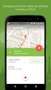
- Complete solution - mobile app records your position while you’re taking great photos and a desktop app geotags your images using recorded data.
- Flawless Lightroom Compatibility - GPX files from the app work flawlessly inside Lightroom’s Map module for geotagging
- Dropbox and Google Drive support - automatically export all your trips as GPX files
- Smart watch app - dedicated app for Android Wear and Pebble to control app from your wrist ! Automatic trip upload - the app automatically sync all your trips ( you can switch to manual uploads in settings)
- Battery usage optimized for whole day of geotagging
- Choose the logging interval and accuracy for whatever you need
- Organized trips history
- Statistics of your trips
- Export to GPX
FREE desktop geotagging app
Adds GPS location to your your JPG or RAW photos quickly and easily! Works both online and offline and there are version for any operating system - Mac OS X, Windows and even Linux
Supported image formats: jpg, nef, cr2, crw, dcr, ciff, erf, orf, k25, kdc, mef, mrw, nrw, pef, raf, tif, tiff, raw, arw, rw2, srf, sr2, srw, x3f, dng
Visit our website for more info http://www.geotagphotos.net
地理标记照片Pro是专业地理标记解决方案 - 所有你需要的地理标记采取外部相机(单反,无反光镜或压缩的)照片。它支持JPG&RAW照片和也可以使用与Lightroom中,光圈,Picasa和其他照片的应用程序,它支持地理标记的照片数据。
尝试3人次免费,然后解锁完整的应用程序的一次性费用。
地理标记照片Pro是由行业专家的好评
- 地理标记年度应用程序由Macworld大会
- 反复推荐的领先Adobe的Lightroom专业人士
- 建议在许多伟大的著作,如Lightroom中4东窗事发,Lightroom中4失踪的常见问题,的Lightroom 4路线图摄影师
- 称赞领先的摄影杂志和网站在世界各地(Techradar,Ephotozine,Fotomaf,Xatakafoto,Lightroom中的秘密,数码,摄影,Pixelmania.nl,的PhotoPlus ...)
关于地理标记照片的最佳事实临
- 完整的解决方案 - 移动应用程序会记录你的位置,你正在做伟大的照片,并使用记录数据的桌面应用地理标记您的图像,同时。
- 完美无瑕的Lightroom兼容性 - 从内Lightroom中的地图模块,地理标记的应用程序完美的工作GPX文件
- Dropbox的和谷歌驱动器支持 - 自动导出所有车次的GPX文件
- 智能手表的应用程序 - 专门的应用程序的Android Wear和卵石从你的手腕控制的应用程序!自动跳闸上传 - 应用程序自动同步您所有的旅行(你可以在设置中切换至手动上传)
- 电池使用地理标记的全天优化
- 选择记录间隔和准确性任何你需要
- 组织的旅行史
- 你的行程统计
- 出口到GPX
免费的桌面应用地理标记
增加了GPS定位到您的JPG或RAW照片快速,轻松地!作品包括在线和离线,有版本,任何操作系统 - 的Mac OS X,Windows和Linux的连
支持的图像格式:JPG,NEF,CR2,CRW,DCR,CIFF,ERF,ORF,K25,KDC,MEF,MRW,北威州,PEF,皇家空军,TIF,TIFF,原材料,ARW,RW2,SRF,SR2,SRW, X3F,DNG
请访问我们的网站了解更多信息http://www.geotagphotos.net
